
Papeles:Europe ISO 3166-1.svg

Kadakkel daytoy a panangipadas ti PNG iti daytoy a papeles ti SVG: 700 × 512 dagiti piksel. Sabali kadagiti resolusion: 320 × 234 dagiti piksel | 640 × 468 dagiti piksel | 1,024 × 749 dagiti piksel | 1,280 × 936 dagiti piksel | 2,560 × 1,872 dagiti piksel.
Kasisigud a papeles (SVG a papeles, babassit ngem 700 × 512 pixels, kadakkel ti papeles: 384 KB)
| Daytoy ket papeles a nagtaud manipud idiay Wikimedia Commons. Ti pakaammo manipud iti bukodna a deskripsion a panid idiay ket naiparang dita baba. Ti Commons ket repositorio dagiti nawaya a nalisensiaan a midia. Mabalinmo ti tumulong. |
Pakabuklan
| Deskripsion |
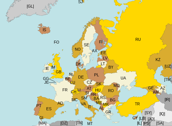
Map of Europe, with ISO 3166-1 pt · en country and territory codes. SVG format. Map legend in Portuguese and English, with name of sovereign state given in parenthesis, where applicable:
Non-European countries and territories featured in map:
|
| Petsa | |
| Taudan | Bukod nga obra |
| Mannurat | Júlio Reis |
| Dagiti sabali a bersion | Without country codes: Europe countries.svg · Only continent boundaries: Europe continents.svg · Country names in Italian: Europa-it-politica-names-big.svg · Including Kosovo: Europe ISO 3166-1 (with Kosovo).svg |
| SVG genesis |
.svg)
Lisensia
Daytoy a papeles ket nalisensiaan babaen ti Creative Commons Attribution-Share Alike 3.0 Unported a lisensia.
- Nawaya ka:
- ti makibingay – ti ag-kopia, agiwaras ken agipatulod ti obra
- ti pagtipon-tipon – ti panagibagay ti obra
- Babaen kadagiti sumaganad a kasasaad:
- pammadayaw – Nasken a mangtedka iti pammadayaw, mangited iti silpo iti lisensia, ken mangibaga no adda dagiti nabaliwan. Mabalinmo nga aramiden iti ania man a pamay-an, ngem iti san a waya a mangisingasing a mangigupit kenka wenno iti panagusarmo.
- makibingay nga agpadapada – No laokam, baliwam, wenno agpartuat manipud iti dayata material, nasken nga iwaras dagiti kontribusionmo babaen ti kapada wenno maitunos a lisensia a kas ti kasisigud.
Pakasaritaan ti papeles
Pinduten iti petsa/oras tapno makita ti papeles a kas naiparang iti dayta a panawen.
| Petsa/Oras | Bassit a ladawan | Dagiti rukod | Agar-aramat | Komentario | |
|---|---|---|---|---|---|
| agdama | 22:43, 10 Agosto 2015 | | 700 × 512 (384 KB) | SiBr4 | Increasing contrast by slightly changing the map colors; splitting Serbia and Montenegro; cropping some more; plain SVG |
| 18:46, 10 Abril 2012 |  | 800 × 512 (421 KB) | Ras67 | "cropped" | |
| 04:52, 13 Marso 2011 |  | 800 × 520 (597 KB) | Chipmunkdavis | Fixing Turkey, adding Gibraltar | |
| 23:11, 22 Agosto 2009 |  | 800 × 520 (599 KB) | Tintazul | Croatia, Palestine | |
| 23:15, 4 Nobiembre 2007 |  | 800 × 520 (601 KB) | Lupo | Re-upload; trying to fix wrong MIME type | |
| 13:06, 14 Agosto 2007 | Awan ti bassit a ladawan | (601 KB) | Tintazul | replaced CS with RS+ME; replaced UK with GB; added AX, SJ, FO, IM, GG, JE | |
| 01:32, 11 Enero 2007 |  | 800 × 520 (594 KB) | Angus | PT → HR | |
| 21:51, 7 Hunio 2006 |  | 800 × 520 (594 KB) | Tintazul | {{Tintazul| |Description=Map of Europe, with ISO 3166-1 <sup>pt · en</sup> country and territory codes. SVG format. Map legend in Portuguese and English, with name of sovereign state given in parenthesis, where appl |
Panagusar iti papeles
Ti sumaganad a panid ket agus-usar iti daytoy a papeles:
Global a panagusar ti papeles
Dagiti sumaganad a wiki ket agus-usar iti daytoy a papeles:
- Panagusar idiay ar.wikipedia.org
- Panagusar idiay arz.wikipedia.org
- Panagusar idiay bg.wikipedia.org
- Panagusar idiay bn.wikipedia.org
- Panagusar idiay cs.wikipedia.org
- Panagusar idiay en.wikipedia.org
- Panagusar idiay eo.wikipedia.org
- Panagusar idiay es.wikipedia.org
- Panagusar idiay fi.wikipedia.org
- Panagusar idiay fo.wikipedia.org
- Panagusar idiay fr.wikipedia.org
- Panagusar idiay gl.wikipedia.org
- Panagusar idiay he.wikipedia.org
- Panagusar idiay id.wikipedia.org
- Panagusar idiay ja.wikipedia.org
- Panagusar idiay ka.wikipedia.org
- Panagusar idiay lt.wikipedia.org
- Panagusar idiay mk.wikipedia.org
- Panagusar idiay nl.wikipedia.org
- Panagusar idiay no.wikipedia.org
- Panagusar idiay pt.wikipedia.org
- Panagusar idiay ru.wikipedia.org
- Panagusar idiay rw.wikipedia.org
- Panagusar idiay si.wikipedia.org
- Panagusar idiay sr.wikipedia.org
- Panagusar idiay su.wikipedia.org
- Panagusar idiay ta.wikipedia.org
- Panagusar idiay www.wikidata.org
- Panagusar idiay zh.wikipedia.org