
Papeles:Bl-map.png
Awan ti mabalin a nangatngato a resolusion.
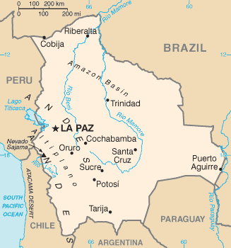
Bl-map.png (327 × 350 dagiti piksel, kadakkel ti papeles: 12 KB, kita ti MIME: image/png)
| Daytoy ket papeles a nagtaud manipud idiay Wikimedia Commons. Ti pakaammo manipud iti bukodna a deskripsion a panid idiay ket naiparang dita baba. Ti Commons ket repositorio dagiti nawaya a nalisensiaan a midia. Mabalinmo ti tumulong. |

|
This locator map image could be re-created using vector graphics as an SVG file. This has several advantages; see Commons:Media for cleanup for more information. If an SVG form of this image is available, please upload it and afterwards replace this template with
{{vector version available|new image name}}.
It is recommended to name the SVG file “Bl-map.svg”—then the template Vector version available (or Vva) does not need the new image name parameter. |
Pakabuklan
| Deskripsion | Bolivia map from CIA World Factbook (since 2 Hunio 2004), converted from original GIF format |
| Petsa | |
| Taudan |
CIA World Factbook |
| Mannurat | United States Central Intelligence Agency |
| Dagiti sabali a bersion |
Lisensia
This image is in the public domain because it contains materials that originally came from the United States Central Intelligence Agency's World Factbook.
|
 |
Derivative works
-
 Bl-map mk.png
македонски -
 Bolivie carte.gif
français -
 Bolivyaharita.jpg
Türkçe -
 Ka Bolivia-Map.png
ქართული


Pakasaritaan ti papeles
Pinduten iti petsa/oras tapno makita ti papeles a kas naiparang iti dayta a panawen.
| Petsa/Oras | Bassit a ladawan | Dagiti rukod | Agar-aramat | Komentario | |
|---|---|---|---|---|---|
| agdama | 09:15, 17 Hunio 2008 | | 327 × 350 (12 KB) | Sevela.p | Remove black line on the left side |
| 17:52, 27 Pebrero 2005 |  | 328 × 350 (12 KB) | Alfio | CIA map of Bolivia |
Panagusar iti papeles
Ti sumaganad a 2 a pampanid ket agus-usar iti daytoy a papeles:
Global a panagusar ti papeles
Dagiti sumaganad a wiki ket agus-usar iti daytoy a papeles:
- Panagusar idiay af.wikipedia.org
- Panagusar idiay ar.wikipedia.org
- Panagusar idiay ast.wikipedia.org
- Panagusar idiay ay.wikipedia.org
- Panagusar idiay be.wikipedia.org
- Panagusar idiay bn.wikipedia.org
- Panagusar idiay bn.wikibooks.org
- Panagusar idiay bo.wikipedia.org
- Panagusar idiay ca.wikipedia.org
- Panagusar idiay cs.wikipedia.org
- Panagusar idiay da.wikipedia.org
- Panagusar idiay de.wikibooks.org
- Panagusar idiay de.wikinews.org
- Panagusar idiay dsb.wikipedia.org
- Panagusar idiay dz.wikipedia.org
- Panagusar idiay el.wikipedia.org
- Panagusar idiay en.wikipedia.org
- List of islands of South America
- Talk:Geography of Bolivia
- Outline of Bolivia
- Irrigation in Bolivia
- Water resources management in Bolivia
- Agriculture in Bolivia
- Module:Location map/data/Bolivia/doc
- Module:Location map/data/Bolivia
- User:Gonzalezmwalter/Bolivia and the International Monetary Fund
- User:Gonzalezmwalter/IMF Bolivia
- Bolivia and the International Monetary Fund
- Panagusar idiay en.wikibooks.org
- Panagusar idiay en.wikinews.org
- Panagusar idiay en.wikisource.org
- Panagusar idiay eo.wikipedia.org
Kitaen ti adu pay a global a panagusar iti daytoy a papeles.