
Papeles:Cg-map.png
Awan ti mabalin a nangatngato a resolusion.
Cg-map.png (326 × 350 dagiti piksel, kadakkel ti papeles: 19 KB, kita ti MIME: image/png)
| Daytoy ket papeles a nagtaud manipud idiay Wikimedia Commons. Ti pakaammo manipud iti bukodna a deskripsion a panid idiay ket naiparang dita baba. Ti Commons ket repositorio dagiti nawaya a nalisensiaan a midia. Mabalinmo ti tumulong. |
Pakabuklan
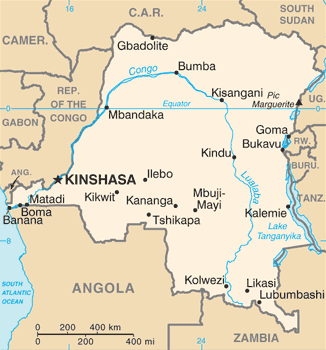
| Deskripsion | Democratic Republic of the Congo map from CIA World Factbook, converted from original GIF format (July 2011 version showing South Sudan) |
| Petsa | |
| Taudan |
CIA World Factbook |
| Mannurat | United States Central Intelligence Agency |
| Dagiti sabali a bersion |
|
Lisensia
This image is in the public domain because it contains materials that originally came from the United States Central Intelligence Agency's World Factbook.
|
 |
Derivative works
Derivatives of 2011 map (showing South Sudan):
-
 Congo CIA map PL.png
polski

Derivatives of 2002 map:
-
 Congo Rep Dem carte.gif
français -
 DRK kaart.png
Afrikaans -
 Karte der Demokratischen Republik Kongo.png
Deutsch -
 Mapa dem rep Kongo.png
čeština


Pakasaritaan ti papeles
Pinduten iti petsa/oras tapno makita ti papeles a kas naiparang iti dayta a panawen.
| Petsa/Oras | Bassit a ladawan | Dagiti rukod | Agar-aramat | Komentario | |
|---|---|---|---|---|---|
| agdama | 10:22, 17 Enero 2022 | | 326 × 350 (19 KB) | Lojwe | Cropped 1 % horizontally, 1 % vertically using CropTool with precise mode. |
| 08:28, 14 Septiembre 2016 |  | 330 × 354 (55 KB) | Yerpo | Reverted to version as of 00:12, 13 July 2011 (UTC) | |
| 00:00, 14 Septiembre 2016 |  | 354 × 330 (20 KB) | SteinsplitterBot | Bot: Image rotated by 90° | |
| 00:12, 13 Hulio 2011 |  | 330 × 354 (55 KB) | Béka~commonswiki | new version with South Sudan, from CIA | |
| 22:53, 4 Marso 2005 |  | 330 × 355 (14 KB) | Alfio | CIA map of Congo Democratic Republic |
Panagusar iti papeles
Ti sumaganad a 2 a pampanid ket agus-usar iti daytoy a papeles:
Global a panagusar ti papeles
Dagiti sumaganad a wiki ket agus-usar iti daytoy a papeles:
- Panagusar idiay ab.wikipedia.org
- Panagusar idiay ar.wikipedia.org
- Panagusar idiay azb.wikipedia.org
- Panagusar idiay be-tarask.wikipedia.org
- Panagusar idiay be.wikipedia.org
- Panagusar idiay bn.wikipedia.org
- Panagusar idiay ca.wikipedia.org
- Panagusar idiay cy.wikipedia.org
- Panagusar idiay da.wikipedia.org
- Panagusar idiay de.wiktionary.org
- Panagusar idiay en.wikipedia.org
- Democratic Republic of the Congo
- Oral polio vaccine AIDS hypothesis
- Portal:Democratic Republic of the Congo
- Index of Democratic Republic of the Congo–related articles
- Wikipedia:WikiProject Democratic Republic of the Congo
- User:SmithBlue/AIDSOPVuniverse
- 2008 Congo football riots
- Sexual violence in the Democratic Republic of the Congo
- User:Francish7
- Template:User WikiProject Democratic Republic of the Congo
- Category:WikiProject Democratic Republic of the Congo participants
- User:NhInsideWriter
- Module:Location map/data/Democratic Republic of the Congo/doc
- Wikipedia:Userboxes/WikiProjects/Regional/03
- User:Crtew/Serge Maheshe
- Wikipedia:Userboxes/WikiProjects/alphabetical/08
- Wikipedia:Userboxes/WikiProjects/alphabetical/09
- Module:Location map/data/Democratic Republic of the Congo
- Wikipedia:Userboxes/Location/Democratic Republic of the Congo
- The Democratic Republic of the Congo and the World Bank
- User:Unbeatable101/sandbox/DRoC
- Panagusar idiay en.wikinews.org
- Panagusar idiay en.wikiversity.org
Kitaen ti adu pay a global a panagusar iti daytoy a papeles.