
Papeles:Danubemap.png
Awan ti mabalin a nangatngato a resolusion.
Danubemap.png (747 × 480 dagiti piksel, kadakkel ti papeles: 601 KB, kita ti MIME: image/png)
| Daytoy ket papeles a nagtaud manipud idiay Wikimedia Commons. Ti pakaammo manipud iti bukodna a deskripsion a panid idiay ket naiparang dita baba. Ti Commons ket repositorio dagiti nawaya a nalisensiaan a midia. Mabalinmo ti tumulong. |

|
This map image could be re-created using vector graphics as an SVG file. This has several advantages; see Commons:Media for cleanup for more information. If an SVG form of this image is available, please upload it and afterwards replace this template with
{{vector version available|new image name}}.
It is recommended to name the SVG file “Danubemap.svg”—then the template Vector version available (or Vva) does not need the new image name parameter. |
Pakabuklan
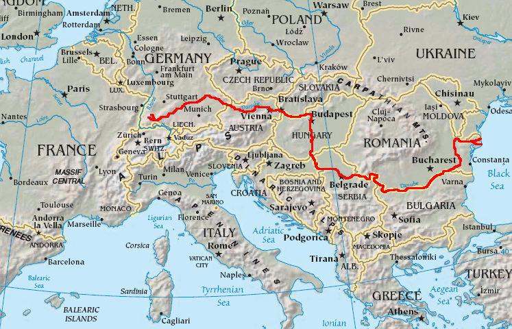
English: Map showing the flow of the Danube River. Uses the map of Europe from the CIA World Factbook.
Lisensia
This image is in the public domain because it contains materials that originally came from the United States Central Intelligence Agency's World Factbook.
|
 |
Pakasaritaan ti papeles
Pinduten iti petsa/oras tapno makita ti papeles a kas naiparang iti dayta a panawen.
| Petsa/Oras | Bassit a ladawan | Dagiti rukod | Agar-aramat | Komentario | |
|---|---|---|---|---|---|
| agdama | 05:34, 12 Pebrero 2007 | | 747 × 480 (601 KB) | Geologik | Map showing the flow of the Danube River. Uses the map of Europe from the CIA World Factbook. |
Panagusar iti papeles
Ti sumaganad a panid ket agus-usar iti daytoy a papeles:
Global a panagusar ti papeles
Dagiti sumaganad a wiki ket agus-usar iti daytoy a papeles:
- Panagusar idiay ang.wikipedia.org
- Panagusar idiay ast.wikipedia.org
- Panagusar idiay av.wikipedia.org
- Panagusar idiay azb.wikipedia.org
- Panagusar idiay ban.wikipedia.org
- Panagusar idiay be-tarask.wikipedia.org
- Panagusar idiay bg.wikipedia.org
Kitaen ti adu pay a global a panagusar iti daytoy a papeles.