
Papeles:Global Temperature Anomaly 1880-2010 (Fig.A).gif
Awan ti mabalin a nangatngato a resolusion.
Global_Temperature_Anomaly_1880-2010_(Fig.A).gif (658 × 474 dagiti piksel, kadakkel ti papeles: 30 KB, kita ti MIME: image/gif)
| Daytoy ket papeles a nagtaud manipud idiay Wikimedia Commons. Ti pakaammo manipud iti bukodna a deskripsion a panid idiay ket naiparang dita baba. Ti Commons ket repositorio dagiti nawaya a nalisensiaan a midia. Mabalinmo ti tumulong. |
Pakabuklan
| Deskripsion |
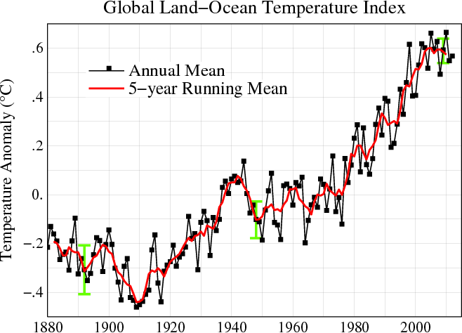
English: Line plot of global mean land-ocean temperature index, 1880 to present, with the base period 1951-1980. The black line is the annual mean and the red line is the five-year running mean. The green bars show uncertainty estimates. [This is an update of Fig. 1A in Hansen et al. (2006).] The graph shows an overall long-term warming trend. |
|||||
| Petsa | ||||||
| Taudan | http://data.giss.nasa.gov/gistemp/ | |||||
| Mannurat | NASA Goddard Institute for Space Studies | |||||
| Pammalubos (Ti panagusar manen iti daytoy a papeles) |
|
|||||
| Dagiti sabali a bersion |
PDF version: File:Global_Temperature_Anomaly_1880-2010_(Fig.A).pdf. SVG version (1880-2010 data, 1961-1990 base period): File:Instrumental Temperature Record (NASA).svg
|

.gif)
.svg)

|
File:Global Temperature Anomaly.svg is a vector version of this file. It should be used in place of this GIF file when not inferior.
File:Global Temperature Anomaly 1880-2010 (Fig.A).gif → File:Global Temperature Anomaly.svg
For more information, see Help:SVG. |
 |
Pakasaritaan ti papeles
Pinduten iti petsa/oras tapno makita ti papeles a kas naiparang iti dayta a panawen.
| Petsa/Oras | Bassit a ladawan | Dagiti rukod | Agar-aramat | Komentario | |
|---|---|---|---|---|---|
| agdama | 15:56, 21 Hunio 2013 | | 658 × 474 (30 KB) | Nigelj | Upload version that has been updated with 2012 data |
| 21:20, 19 Enero 2012 |  | 652 × 474 (31 KB) | Simplex1swrhs | I have uploaded a new version of the NASA global temperature graph with 2011 data. | |
| 15:58, 19 Marso 2011 |  | 652 × 474 (31 KB) | Simplex1swrhs | Switched back to the NASA GISS "Global Land-Ocean Temperature Index" graph with 2010 data update. {{Information |Description= Line plot of global mean land-ocean temperature index, 1880 to present, with the base period 1951-1980. The dotted black line is | |
| 20:05, 3 Marso 2011 |  | 655 × 439 (30 KB) | OKIsItJustMe | {{Information |Description ={{en|1=Line plot of global mean land-ocean temperature index, 1880 to present, with the base period 1951-1980. The dotted black line is the annual mean and the solid red line is the five-year mean. The green bars show uncert |
Panagusar iti papeles
Awan ti pampanid nga agus-usar iti daytoy a papeles.
Global a panagusar ti papeles
Dagiti sumaganad a wiki ket agus-usar iti daytoy a papeles:
- Panagusar idiay ar.wikipedia.org
- Panagusar idiay en.wikipedia.org
- Panagusar idiay fr.wikipedia.org
- Panagusar idiay ko.wikipedia.org
- Panagusar idiay no.wikipedia.org
- Panagusar idiay vi.wikipedia.org
- Panagusar idiay zh.wikipedia.org
.gif)