
Papeles:Indian subcontinent CIA.png

Kadakkel daytoy a panagipadas: 467 × 599 dagiti piksel. Sabali kadagiti resolusion: 187 × 240 dagiti piksel | 374 × 480 dagiti piksel | 599 × 768 dagiti piksel | 798 × 1,024 dagiti piksel | 1,656 × 2,124 dagiti piksel.
Kasisigud a papeles (1,656 × 2,124 dagiti piksel, kadakkel ti papeles: 909 KB, kita ti MIME: image/png)
| Daytoy ket papeles a nagtaud manipud idiay Wikimedia Commons. Ti pakaammo manipud iti bukodna a deskripsion a panid idiay ket naiparang dita baba. Ti Commons ket repositorio dagiti nawaya a nalisensiaan a midia. Mabalinmo ti tumulong. |
| Deskripsion |
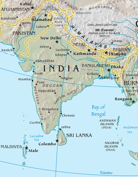
English: Map of the Indian subcontinent. Cropped from the CIA World Factbook map of Asia. |
| Taudan | https://www.cia.gov/library/publications/resources/the-world-factbook/wfbExt/region_sas.html |
| Mannurat | CIA |
This image is in the public domain because it contains materials that originally came from the United States Central Intelligence Agency's World Factbook.
|
 |
Pakasaritaan ti papeles
Pinduten iti petsa/oras tapno makita ti papeles a kas naiparang iti dayta a panawen.
| Petsa/Oras | Bassit a ladawan | Dagiti rukod | Agar-aramat | Komentario | |
|---|---|---|---|---|---|
| agdama | 21:38, 23 Enero 2009 | | 1,656 × 2,124 (909 KB) | AxelBoldt | {{Information |Description={{en|Map of the Indian subcontinent. Cropped from the CIA World Factbook map of Asia.}} |Source=https://www.cia.gov/library/publications/the-world-factbook/reference_maps/asia.html |Date= |Author=CIA |Permission= |other_version |
Panagusar iti papeles
Ti sumaganad a panid ket agus-usar iti daytoy a papeles:
Global a panagusar ti papeles
Dagiti sumaganad a wiki ket agus-usar iti daytoy a papeles:
- Panagusar idiay ar.wikipedia.org
- Panagusar idiay az.wikipedia.org
- Panagusar idiay ba.wikipedia.org
- Panagusar idiay be.wikipedia.org
- Panagusar idiay bs.wikipedia.org
- Panagusar idiay ce.wikipedia.org
- Panagusar idiay cs.wikipedia.org
- Panagusar idiay cv.wikipedia.org
- Panagusar idiay de.wikipedia.org
- Panagusar idiay fi.wikipedia.org
- Panagusar idiay is.wikipedia.org
- Panagusar idiay ja.wikipedia.org
- Panagusar idiay ka.wikipedia.org
- Panagusar idiay kk.wikipedia.org
- Panagusar idiay krc.wikipedia.org
- Panagusar idiay ml.wikipedia.org
- Panagusar idiay mrj.wikipedia.org
- Panagusar idiay pa.wikipedia.org
- Panagusar idiay pl.wikipedia.org
- Panagusar idiay pnb.wikipedia.org
- Panagusar idiay pt.wikipedia.org
- Panagusar idiay ru.wikipedia.org
- Panagusar idiay sh.wikipedia.org
- Panagusar idiay sr.wikipedia.org
- Panagusar idiay sv.wikipedia.org
- Panagusar idiay ta.wikipedia.org
- Panagusar idiay tt.wikipedia.org
- Panagusar idiay uk.wikipedia.org
- Panagusar idiay ur.wikipedia.org
- Panagusar idiay xmf.wikipedia.org