
Papeles:Karte 13 Alte Orte.png

Kadakkel daytoy a panagipadas: 800 × 529 dagiti piksel. Sabali kadagiti resolusion: 320 × 211 dagiti piksel | 640 × 423 dagiti piksel | 1,024 × 677 dagiti piksel | 1,280 × 846 dagiti piksel | 2,500 × 1,652 dagiti piksel.
Kasisigud a papeles (2,500 × 1,652 dagiti piksel, kadakkel ti papeles: 512 KB, kita ti MIME: image/png)
| Daytoy ket papeles a nagtaud manipud idiay Wikimedia Commons. Ti pakaammo manipud iti bukodna a deskripsion a panid idiay ket naiparang dita baba. Ti Commons ket repositorio dagiti nawaya a nalisensiaan a midia. Mabalinmo ti tumulong. |
Pakabuklan
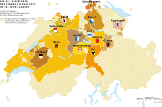
| Deskripsion |
Deutsch: Die 13 «Alten Orte» (alte Kantone) der schweizerischen Eidgenossenschaft und ihr direkt beherrschtes Territorium im 18. Jahrhundert |
|
| Petsa | 3.5.2007 | |
| Taudan | Bukod nga obra | |
| Mannurat | Marco Zanoli (sidonius 19:14, 3 May 2007 (UTC)) | |
| Pammalubos (Ti panagusar manen iti daytoy a papeles) |
|
|
| Dagiti sabali a bersion |
|


|
This historical map image could be re-created using vector graphics as an SVG file. This has several advantages; see Commons:Media for cleanup for more information. If an SVG form of this image is available, please upload it and afterwards replace this template with
{{vector version available|new image name}}.
It is recommended to name the SVG file “Karte 13 Alte Orte.svg”—then the template Vector version available (or Vva) does not need the new image name parameter. |
Pakasaritaan ti papeles
Pinduten iti petsa/oras tapno makita ti papeles a kas naiparang iti dayta a panawen.
| Petsa/Oras | Bassit a ladawan | Dagiti rukod | Agar-aramat | Komentario | |
|---|---|---|---|---|---|
| agdama | 08:59, 8 Marso 2022 | | 2,500 × 1,652 (512 KB) | Sidonius | minor adjustements, higher resolution |
| 04:51, 4 Hulio 2010 |  | 1,200 × 761 (236 KB) | DcoetzeeBot | Remove watermark, add author and license data to image metadata, decrease filesize with pngcrush | |
| 13:35, 3 Mayo 2007 |  | 1,200 × 761 (235 KB) | Sidonius | {{Information |Description={{de|Die 13 «Alten Orte» (alte Kantone) der schweizerischen Eidgenossenschaft und ihr direkt beherrschtes Territorium im 18. Jahrhundert}} |Source=own work |Date=3.5.2007 |Author= |Permission={{A |
Panagusar iti papeles
Ti sumaganad a panid ket agus-usar iti daytoy a papeles:
Global a panagusar ti papeles
Dagiti sumaganad a wiki ket agus-usar iti daytoy a papeles:
- Panagusar idiay als.wikipedia.org
- Panagusar idiay bn.wikipedia.org
- Panagusar idiay cs.wikipedia.org
- Panagusar idiay de.wikipedia.org
- Panagusar idiay en.wikipedia.org
- Panagusar idiay eo.wikipedia.org
- Panagusar idiay et.wikipedia.org
- Panagusar idiay fi.wikipedia.org
- Panagusar idiay fr.wikipedia.org
- Panagusar idiay gl.wikipedia.org
- Panagusar idiay he.wikipedia.org
- Panagusar idiay hy.wikipedia.org
- Panagusar idiay it.wikipedia.org
- Panagusar idiay ka.wikipedia.org
- Panagusar idiay ko.wikipedia.org
- Panagusar idiay mt.wikipedia.org
- Panagusar idiay nl.wikipedia.org
- Panagusar idiay sl.wikipedia.org
- Panagusar idiay sv.wikipedia.org
- Panagusar idiay uk.wikipedia.org
- Panagusar idiay zh.wikipedia.org