
Papeles:Lombardy.satellite.jpg

Kadakkel daytoy a panagipadas: 600 × 600 dagiti piksel. Sabali kadagiti resolusion: 240 × 240 dagiti piksel | 480 × 480 dagiti piksel | 768 × 768 dagiti piksel | 1,024 × 1,024 dagiti piksel | 2,048 × 2,048 dagiti piksel | 4,055 × 4,055 dagiti piksel.
Kasisigud a papeles (4,055 × 4,055 dagiti piksel, kadakkel ti papeles: 15.2 MB, kita ti MIME: image/jpeg)
| Daytoy ket papeles a nagtaud manipud idiay Wikimedia Commons. Ti pakaammo manipud iti bukodna a deskripsion a panid idiay ket naiparang dita baba. Ti Commons ket repositorio dagiti nawaya a nalisensiaan a midia. Mabalinmo ti tumulong. |
Pakabuklan
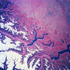
| Deskripsion | Several elongated lakes (dark features) are identifiable in this southerly view of the Italian-Swiss border. The elongated lakes are the creation of alpine (or valley) glaciers that moved generally southward through this section of the Italian Alps over 12000 years ago. From west to east the four larger lakes are Maggiore (lower right corner), Lugana, Como, and d'Iseo (upper left corner). Smaller lakes (also dark features) are visible at the southern end of Lake Como (center of image) and Lake Maggiore. Subtle faults that are perpendicular to the southern end of the lakes can be traced east to west across the landscape at the base of the Italian Alps. Glaciated, U-shaped valleys are discernible north and northeast of the lakes. The color infrared helps to identify the densely vegetated mountain slopes where the forested land (green vegetation) is shown as concentrations of reddish patterns. The relatively flat plains of the highly industrialized and agriculturally productive Po River Valley (upper third of image) presents a dramatically different looking terrain than the snow covered mountainous region of northern Italy. |
| Petsa | Winter/Spring 1997 |
| Taudan | Here |
| Mannurat | Image Science and Analysis Laboratory, NASA-Johnson Space Center. 18 Mar. 2005. "Earth from Space - Image Information." |
This image or video was catalogued by one of the centers of the United States National Aeronautics and Space Administration (NASA) under Photo ID: NM23-776-834. This tag does not indicate the copyright status of the attached work. A normal copyright tag is still required. See Commons:Licensing. Other languages:
|
Lisensia
| This file is in the public domain in the United States because it was solely created by NASA. NASA copyright policy states that "NASA material is not protected by copyright unless noted". (See Template:PD-USGov, NASA copyright policy page or JPL Image Use Policy.) | ||
 |
Warnings:
|
Pakasaritaan ti papeles
Pinduten iti petsa/oras tapno makita ti papeles a kas naiparang iti dayta a panawen.
| Petsa/Oras | Bassit a ladawan | Dagiti rukod | Agar-aramat | Komentario | |
|---|---|---|---|---|---|
| agdama | 21:18, 24 Hulio 2023 | | 4,055 × 4,055 (15.2 MB) | Don-vip | |
| 19:05, 5 Agosto 2006 |  | 639 × 639 (391 KB) | Lange~commonswiki | {{Information |Description= Several elongated lakes (dark features) are identifiable in this southerly view of the Italian-Swiss border. The elongated lakes are the creation of alpine (or valley) glaciers that moved generally southward through this sectio |
Panagusar iti papeles
Ti sumaganad a panid ket agus-usar iti daytoy a papeles:
Global a panagusar ti papeles
Dagiti sumaganad a wiki ket agus-usar iti daytoy a papeles:
- Panagusar idiay arz.wikipedia.org
- Panagusar idiay ast.wikipedia.org
- Panagusar idiay az.wikipedia.org
- Panagusar idiay bg.wikipedia.org
- Panagusar idiay ca.wikipedia.org
- Panagusar idiay cy.wikipedia.org
- Panagusar idiay de.wikivoyage.org
- Panagusar idiay diq.wikipedia.org
- Panagusar idiay fi.wikipedia.org
- Panagusar idiay fr.wikipedia.org
- Panagusar idiay fr.wikivoyage.org
- Panagusar idiay ga.wikipedia.org
- Panagusar idiay gd.wikipedia.org
- Panagusar idiay gl.wikipedia.org
- Panagusar idiay he.wikipedia.org
- Panagusar idiay hy.wikipedia.org
- Panagusar idiay ia.wikipedia.org
- Panagusar idiay id.wikipedia.org
- Panagusar idiay it.wikipedia.org
- Panagusar idiay ka.wikipedia.org
- Panagusar idiay ku.wikipedia.org
- Panagusar idiay la.wikipedia.org
- Panagusar idiay mzn.wikipedia.org
- Panagusar idiay no.wikipedia.org
- Panagusar idiay oc.wikipedia.org
- Panagusar idiay pl.wikipedia.org
- Panagusar idiay ro.wikipedia.org
- Panagusar idiay ru.wikipedia.org
- Panagusar idiay ru.wikinews.org
- Panagusar idiay sl.wikipedia.org
- Panagusar idiay sr.wikipedia.org
- Panagusar idiay tt.wikipedia.org
- Panagusar idiay uk.wikipedia.org
- Panagusar idiay vec.wikipedia.org
- Panagusar idiay vi.wikipedia.org
- Panagusar idiay www.wikidata.org