
Papeles:Malay language Spoken Area Map v1.png
Awan ti mabalin a nangatngato a resolusion.
Malay_language_Spoken_Area_Map_v1.png (333 × 154 dagiti piksel, kadakkel ti papeles: 4 KB, kita ti MIME: image/png)
| Daytoy ket papeles a nagtaud manipud idiay Wikimedia Commons. Ti pakaammo manipud iti bukodna a deskripsion a panid idiay ket naiparang dita baba. Ti Commons ket repositorio dagiti nawaya a nalisensiaan a midia. Mabalinmo ti tumulong. |
Pakabuklan

|
This linguistic map image could be re-created using vector graphics as an SVG file. This has several advantages; see Commons:Media for cleanup for more information. If an SVG form of this image is available, please upload it and afterwards replace this template with
{{vector version available|new image name}}.
It is recommended to name the SVG file “Malay language Spoken Area Map v1.svg”—then the template Vector version available (or Vva) does not need the new image name parameter. |
| Deskripsion |
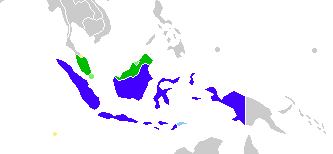
English: This is crop and edit of a .png export of the image at File:BlankMap-World6.svg. The original author released that image into the public domain for any use. This version is released under the CC-Zero license. |
| Petsa | 13 Pebrero 2011 (original upload date) |
| Taudan | Transferred from en.wikipedia to Commons by Zscout370 using CommonsHelper. |
| Mannurat | True at English Wikipedia |
Lisensia
Ni True at English Wikipedia, ti agtengtengel ti karbengan ti kopia iti daytoy nga obra, ket agipablaak babaen ti sumaganad a lisensia:
| Daytoy a papeles ket nalisensiaan babaen ti Creative Commons CC0 1.0 Universal Public Domain Dedication. | |
| Ti tao a tumaripnong ti obra a daytoy a kasuratan ket nairuknoy na ti obra iti pagturayan a publiko babaen ti pangiwagsak iti amin kadagiti karbengan iti obra iti sangalubongan babaen ti karbengan ti kopia a linteg, a mairaman amin a maikabagian ken dagiti karruba a karbengan, iti kalawa a maipalubusan babaen ti linteg. Makopiam, mabaliwam,maiwaras ken itungpal ti obra, uray ti komersial a pang-panggep, amin nga awan ti dumawat ti pammalubos.
|
Kasisigud a listaan pang-ipan
The original description page was here. All following user names refer to en.wikipedia.
- 2012-02-20 03:34 Kwamikagami 333×154× (4555 bytes) correct area in Thailand, add Cocos Isl.
- 2012-02-20 03:17 Kwamikagami 333×154× (4570 bytes) Reverted to version as of 23:23, 13 February 2011
- 2011-09-14 23:58 Niduzzi 736×386× (33038 bytes)
- 2011-02-13 23:23 True 333×154× (4570 bytes) This is crop and edit of a .png export of the image at http://en.wikipedia.org/wiki/File:BlankMap-World6.svg. The original author released that image into the public domain for any use. This version is released under the CC-Zero license.
Pakasaritaan ti papeles
Pinduten iti petsa/oras tapno makita ti papeles a kas naiparang iti dayta a panawen.
| Petsa/Oras | Bassit a ladawan | Dagiti rukod | Agar-aramat | Komentario | |
|---|---|---|---|---|---|
| agdama | 08:23, 25 Pebrero 2022 | | 333 × 154 (4 KB) | Kwamikagami | no longer a map of where Malay is spoken |
| 05:52, 26 Oktubre 2018 |  | 4,387 × 1,922 (336 KB) | Bennylin | Edit some colors | |
| 05:40, 26 Oktubre 2018 |  | 4,300 × 1,918 (535 KB) | Bennylin | Change ugly map with PNG version of File:Maritime South East Asia.svg | |
| 04:51, 21 Hunio 2012 |  | 333 × 154 (4 KB) | File Upload Bot (Magnus Manske) | Transfered from en.wikipedia by User:zscout370 using CommonsHelper |
Panagusar iti papeles
Awan ti pampanid nga agus-usar iti daytoy a papeles.
Global a panagusar ti papeles
Dagiti sumaganad a wiki ket agus-usar iti daytoy a papeles:
- Panagusar idiay ckb.wikipedia.org
- Panagusar idiay el.wikipedia.org
- Panagusar idiay en.wikipedia.org
- Panagusar idiay fa.wikipedia.org
- Panagusar idiay frr.wikipedia.org
- Panagusar idiay id.wikipedia.org
- Panagusar idiay incubator.wikimedia.org
- Panagusar idiay mi.wikipedia.org
- Panagusar idiay nl.wikipedia.org
- Panagusar idiay zh.wikipedia.org