
Papeles:Map of Wyoming NA.png

Kadakkel daytoy a panagipadas: 776 × 600 dagiti piksel. Sabali kadagiti resolusion: 311 × 240 dagiti piksel | 621 × 480 dagiti piksel | 994 × 768 dagiti piksel | 1,280 × 989 dagiti piksel | 2,122 × 1,640 dagiti piksel.
Kasisigud a papeles (2,122 × 1,640 dagiti piksel, kadakkel ti papeles: 2.99 MB, kita ti MIME: image/png)
| Daytoy ket papeles a nagtaud manipud idiay Wikimedia Commons. Ti pakaammo manipud iti bukodna a deskripsion a panid idiay ket naiparang dita baba. Ti Commons ket repositorio dagiti nawaya a nalisensiaan a midia. Mabalinmo ti tumulong. |
Pakabuklan
| Deskripsion |
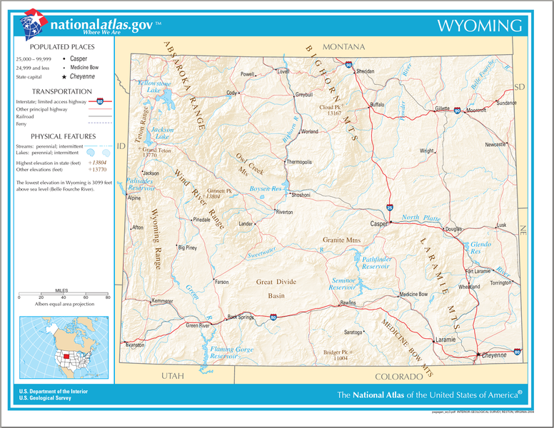
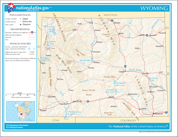
English: Map of Wyoming. |
| Petsa | |
| Taudan | National Atlas |
| Mannurat |
Lisensia
This map was obtained from an edition of the National Atlas of the United States. Like almost all works of the U.S. federal government, works from the National Atlas are in the public domain in the United States.
Online access: NationalAtlas.gov | 1970 print edition: Library of Congress, Perry-Castañeda Library
|
Pakasaritaan ti papeles
Pinduten iti petsa/oras tapno makita ti papeles a kas naiparang iti dayta a panawen.
| Petsa/Oras | Bassit a ladawan | Dagiti rukod | Agar-aramat | Komentario | |
|---|---|---|---|---|---|
| agdama | 09:35, 15 Agosto 2006 | | 2,122 × 1,640 (2.99 MB) | Huebi~commonswiki | {{Information| |Description=Map of Wyoming |Source=[http://www.nationalatlas.gov National Atlas] }} Category:Maps of the United States Category:Maps of Wyoming {{PD-USGov-Atlas}} |
Panagusar iti papeles
Ti sumaganad a 3 a pampanid ket agus-usar iti daytoy a papeles:
Global a panagusar ti papeles
Dagiti sumaganad a wiki ket agus-usar iti daytoy a papeles:
- Panagusar idiay bh.wikipedia.org
- Panagusar idiay ca.wikipedia.org
- Panagusar idiay de.wikipedia.org
- Panagusar idiay en.wikipedia.org
- Panagusar idiay hu.wikipedia.org
- Panagusar idiay incubator.wikimedia.org
- Panagusar idiay it.wikipedia.org
- Panagusar idiay kn.wikipedia.org
- Panagusar idiay ml.wikipedia.org
- Panagusar idiay simple.wikipedia.org
- Panagusar idiay si.wikipedia.org
- Panagusar idiay sw.wikipedia.org
- Panagusar idiay szl.wikipedia.org
- Panagusar idiay uz.wikipedia.org
- Panagusar idiay zea.wikipedia.org