
Papeles:Mapanuepe Lake-before & after.gif

Kadakkel daytoy a panagipadas: 388 × 599 dagiti piksel. Sabali kadagiti resolusion: 155 × 240 dagiti piksel | 500 × 772 dagiti piksel.
Kasisigud a papeles (500 × 772 dagiti piksel, kadakkel ti papeles: 90 KB, kita ti MIME: image/gif)
| Daytoy ket papeles a nagtaud manipud idiay Wikimedia Commons. Ti pakaammo manipud iti bukodna a deskripsion a panid idiay ket naiparang dita baba. Ti Commons ket repositorio dagiti nawaya a nalisensiaan a midia. Mabalinmo ti tumulong. |
Pakabuklan
| Deskripsion |
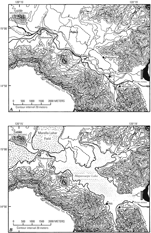
English: The map of Mapanuepe Valley before the eruption of Mount Pinatubo and after the lake has formed. |
| Petsa | |
| Taudan | http://pubs.usgs.gov/pinatubo/umbal/fig16.gif |
| Mannurat | U.S. Geological Survey |
| Pammalubos (Ti panagusar manen iti daytoy a papeles) |
Work by U.S. Government. |
Lisensia
This image is in the public domain in the United States because it only contains materials that originally came from the United States Geological Survey, an agency of the United States Department of the Interior. For more information, see the official USGS copyright policy.
|
Pakasaritaan ti papeles
Pinduten iti petsa/oras tapno makita ti papeles a kas naiparang iti dayta a panawen.
| Petsa/Oras | Bassit a ladawan | Dagiti rukod | Agar-aramat | Komentario | |
|---|---|---|---|---|---|
| agdama | 20:20, 17 Hunio 2011 | | 500 × 772 (90 KB) | Briarfallen | {{Information |Description ={{en|1=The map of Mapanuepe Valley before the eruption of Mount Pinatubo and after the lake has formed. }} |Source =http://pubs.usgs.gov/pinatubo/umbal/fig16.gif |Author =U.S. Geological Survey |Date |
Panagusar iti papeles
Ti sumaganad a panid ket agus-usar iti daytoy a papeles:
Global a panagusar ti papeles
Dagiti sumaganad a wiki ket agus-usar iti daytoy a papeles:
- Panagusar idiay en.wikipedia.org