
Papeles:Mexico City ESA412648.jpg

Kasisigud a papeles (7,288 × 4,599 dagiti piksel, kadakkel ti papeles: 9.14 MB, kita ti MIME: image/jpeg)
| Daytoy ket papeles a nagtaud manipud idiay Wikimedia Commons. Ti pakaammo manipud iti bukodna a deskripsion a panid idiay ket naiparang dita baba. Ti Commons ket repositorio dagiti nawaya a nalisensiaan a midia. Mabalinmo ti tumulong. |
Pakabuklan
| Deskripsion |
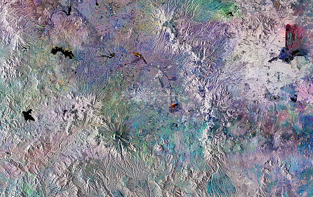
English: The Copernicus Sentinel-1 mission takes us over Mexico City. This huge, densely-populated capital can be seen in the top right of the image. It is home to almost nine million people, with the Greater Mexico City area recording a population of over 21 million. This makes it the largest Spanish-speaking city in the world.
This striking image has been created using three Copernicus Sentinel-1 acquisitions from 28 July, 27 August and 26 September 2018, overlaid in red, green and blue, respectively. Where we see explosions of colour, changes have occurred between the different acquisitions. In the left of the image, three bodies of water are shown in black: Villa Victoria, Valle de Bravo, and Tepetitlán. Water is significant to the development of Mexico City, which is thought to have been built over a lake by the Aztecs around 1325. Today, the city finds itself in a precarious situation in terms of water supply in spite of the regular flash floods and heavy rainfall it experiences during the wet season from June and September. In the top right, we can see the round structure of El Caracol meaning ‘the snail’ in Spanish. Currently used as a reservoir for industrial facilities within Mexico City, there are plans for this to become a wastewater treatment plant. A 62 km-long sewer tunnel is also due to begin operating this year. The Cumbres del Ajusco national park is shown to the southwest of the capital, in an area of the image that shows colourful dots forming a circle. Famous for being up to almost 4000 m above sea level at its highest elevation, it is one of many national parks surrounding the capital. Volcanoes are also dotted around this area. Popocatépetl, to the south east of Mexico City, last erupted in September 2018. Sentinel-1 is a two-satellite mission to supply the coverage and data delivery needed for Europe’s Copernicus environmental monitoring programme. The satellites each carry an advanced radar instrument to provide an all-weather, day-and-night supply of imagery of Earth’s surface. This image is also featured on theEarth from Space video programme. |
| Petsa | Taken in 2018 |
| Taudan | http://www.esa.int/spaceinimages/Images/2018/11/Mexico_City |
| Mannurat | European Space Agency |
| Pammalubos (Ti panagusar manen iti daytoy a papeles) |
contains modified Copernicus Sentinel data (2018), processed by ESA,CC BY-SA 3.0 IGO |
| Dagiti sabali a bersion |
|
| Title | Mexico City |
| System | Copernicus |
| Set | Earth observation image of the week |
| Mission | Sentinel-1 |
| Activity | Observing the Earth |

Lisensia
This media was created by the European Space Agency (ESA).
Where expressly so stated, images or videos are covered by the Creative Commons Attribution-ShareAlike 3.0 IGO (CC BY-SA 3.0 IGO) licence, ESA being an Intergovernmental Organisation (IGO), as defined by the CC BY-SA 3.0 IGO licence. The user is allowed under the terms and conditions of the CC BY-SA 3.0 IGO license to Reproduce, Distribute and Publicly Perform the ESA images and videos released under CC BY-SA 3.0 IGO licence and the Adaptations thereof, without further explicit permission being necessary, for as long as the user complies with the conditions and restrictions set forth in the CC BY-SA 3.0 IGO licence, these including that:
See the ESA Creative Commons copyright notice for complete information, and this article for additional details.
|
 | |
This file is licensed under the Creative Commons Attribution-ShareAlike 3.0 IGO license. Pammadayaw: ESA, CC BY-SA IGO 3.0
| ||

|
This image contains data from a satellite in the Copernicus Programme, such as Sentinel-1, Sentinel-2 or Sentinel-3. Attribution is required when using this image.
Pammadayaw: Contains modified Copernicus Sentinel data 2018
The use of Copernicus Sentinel Data is regulated under EU law (Commission Delegated Regulation (EU) No 1159/2013 and Regulation (EU) No 377/2014). Relevant excerpts:
Free access shall be given to GMES dedicated data [...] made available through GMES dissemination platforms [...].
Access to GMES dedicated data [...] shall be given for the purpose of the following use in so far as it is lawful:
GMES dedicated data [...] may be used worldwide without limitations in time.
GMES dedicated data and GMES service information are provided to users without any express or implied warranty, including as regards quality and suitability for any purpose. |
Pakasaritaan ti papeles
Pinduten iti petsa/oras tapno makita ti papeles a kas naiparang iti dayta a panawen.
| Petsa/Oras | Bassit a ladawan | Dagiti rukod | Agar-aramat | Komentario | |
|---|---|---|---|---|---|
| agdama | 13:14, 3 Abril 2019 | | 7,288 × 4,599 (9.14 MB) | Fæ | European Space Agency, Id 412648, http://www.esa.int/spaceinimages/Images/2018/11/Mexico_City, User:Fæ/Project_list/ESA |
Panagusar iti papeles
Ti sumaganad a panid ket agus-usar iti daytoy a papeles:
Global a panagusar ti papeles
Dagiti sumaganad a wiki ket agus-usar iti daytoy a papeles:
- Panagusar idiay ar.wikipedia.org
- Panagusar idiay arz.wikipedia.org
- Panagusar idiay ast.wikipedia.org
- Panagusar idiay ca.wikipedia.org
- Panagusar idiay ceb.wikipedia.org
- Panagusar idiay ce.wikipedia.org
- Panagusar idiay cy.wikipedia.org
- Panagusar idiay da.wikipedia.org
- Panagusar idiay de.wikivoyage.org
- Panagusar idiay el.wikipedia.org
- Panagusar idiay eo.wikipedia.org
- Panagusar idiay fi.wikipedia.org
- Panagusar idiay fr.wikivoyage.org
- Panagusar idiay ga.wikipedia.org
- Panagusar idiay gl.wikipedia.org
- Panagusar idiay he.wikipedia.org
- Panagusar idiay hy.wikipedia.org
- Panagusar idiay ia.wikipedia.org
- Panagusar idiay mzn.wikipedia.org
- Panagusar idiay nn.wikipedia.org
- Panagusar idiay no.wikipedia.org
- Panagusar idiay pl.wikipedia.org
- Panagusar idiay pt.wikipedia.org
- Panagusar idiay ro.wikipedia.org
- Panagusar idiay ru.wikipedia.org
- Panagusar idiay sk.wikipedia.org
- Panagusar idiay sr.wikipedia.org
- Panagusar idiay tt.wikipedia.org
- Panagusar idiay uk.wikipedia.org
- Panagusar idiay vec.wikipedia.org
- Panagusar idiay vi.wikipedia.org
- Panagusar idiay www.wikidata.org