
Papeles:Naie in Hokkaido Prefecture Ja.svg

Kasisigud a papeles (SVG a papeles, babassit ngem 800 × 872 pixels, kadakkel ti papeles: 42 KB)
| Daytoy ket papeles a nagtaud manipud idiay Wikimedia Commons. Ti pakaammo manipud iti bukodna a deskripsion a panid idiay ket naiparang dita baba. Ti Commons ket repositorio dagiti nawaya a nalisensiaan a midia. Mabalinmo ti tumulong. |
Pakabuklan
| Deskripsion |
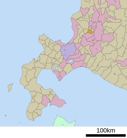
English: Location of Naie in Hokkaido Prefecture
日本語: 北海道空知郡奈井江町の位置 |
||
| Petsa | (UTC) | ||
| Taudan | ja:File:基礎自治体位置図 01424.svg | ||
| Mannurat | ja:User:Lincun | ||
| Pammalubos (Ti panagusar manen iti daytoy a papeles) |
|
Lisensia

|
Maited ti pammalubos ti agkopia, agiwaras ken/wenno mangbaliw iti daytoy a dokumento babaen ti termino iti GNU Free Documentation License, Bersion 1.2 wenno ti ania man a kinaudi a bersion babaen ti Free Software Foundation; nga awan dagiti Sabsabali a Paset, awan dagiti Sanguan nga Aklub a Teksto, ken dagiti Likudan nga Aklub a Teksto. Ti kopia ti lisensia ket nairaman iti paset a natituluan iti GNU Free Documentation License. |
- Nawaya ka:
- ti makibingay – ti ag-kopia, agiwaras ken agipatulod ti obra
- ti pagtipon-tipon – ti panagibagay ti obra
- Babaen kadagiti sumaganad a kasasaad:
- pammadayaw – Nasken a mangtedka iti pammadayaw, mangited iti silpo iti lisensia, ken mangibaga no adda dagiti nabaliwan. Mabalinmo nga aramiden iti ania man a pamay-an, ngem iti san a waya a mangisingasing a mangigupit kenka wenno iti panagusarmo.
- makibingay nga agpadapada – No laokam, baliwam, wenno agpartuat manipud iti dayata material, nasken nga iwaras dagiti kontribusionmo babaen ti kapada wenno maitunos a lisensia a kas ti kasisigud.
Pakasaritaan ti papeles
Pinduten iti petsa/oras tapno makita ti papeles a kas naiparang iti dayta a panawen.
| Petsa/Oras | Bassit a ladawan | Dagiti rukod | Agar-aramat | Komentario | |
|---|---|---|---|---|---|
| agdama | 13:58, 17 Marso 2021 | | 800 × 872 (42 KB) | AridCeption | Reverted to version as of 07:57, 6 May 2009 (UTC) |
| 06:44, 18 Nobiembre 2017 |  | 434 × 580 (10 KB) | IRTC1015 | Updated version from ja:ファイル:基礎自治体位置図 01424.svg | |
| 07:57, 6 Mayo 2009 |  | 800 × 872 (42 KB) | Monaneko | {{Information |Description={{en|1=Location of Naie in Hokkaido Prefecture}} {{ja|1=北海道空知郡奈井江町の位置}} |Source=ja:File:基礎自治体位置図 01424.svg |Author=ja:User:Lincun |Date=2007-11-10 08:40 (UTC) |Permission=GFDL |
Panagusar iti papeles
Ti sumaganad a panid ket agus-usar iti daytoy a papeles:
Global a panagusar ti papeles
Dagiti sumaganad a wiki ket agus-usar iti daytoy a papeles:
- Panagusar idiay ar.wikipedia.org
- Panagusar idiay arz.wikipedia.org
- Panagusar idiay en.wikipedia.org
- Panagusar idiay fa.wikipedia.org
- Panagusar idiay id.wikipedia.org
- Panagusar idiay it.wikipedia.org
- Panagusar idiay ko.wikipedia.org
- Panagusar idiay my.wikipedia.org
- Panagusar idiay pl.wikipedia.org
- Panagusar idiay uk.wikipedia.org
- Panagusar idiay vi.wikipedia.org
- Panagusar idiay www.wikidata.org