
Papeles:Oceanias Regions.png
Awan ti mabalin a nangatngato a resolusion.
Oceanias_Regions.png (552 × 350 dagiti piksel, kadakkel ti papeles: 20 KB, kita ti MIME: image/png)
| Daytoy ket papeles a nagtaud manipud idiay Wikimedia Commons. Ti pakaammo manipud iti bukodna a deskripsion a panid idiay ket naiparang dita baba. Ti Commons ket repositorio dagiti nawaya a nalisensiaan a midia. Mabalinmo ti tumulong. |

|
This locator map image could be re-created using vector graphics as an SVG file. This has several advantages; see Commons:Media for cleanup for more information. If an SVG form of this image is available, please upload it and afterwards replace this template with
{{vector version available|new image name}}.
It is recommended to name the SVG file “Oceanias Regions.svg”—then the template Vector version available (or Vva) does not need the new image name parameter. |
| Deskripsion |
Català: Regions d'Oceania.
Čeština: Regiony Oceánie.
Deutsch: Regionen Ozeaniens.
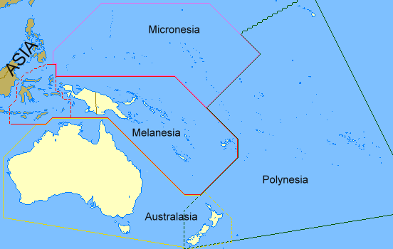
English: Regions of Oceania. Regions of Oceania: In its narrow usage Oceania refers to Polynesia (including New Zealand), Melanesia (including New Guinea) and Micronesia. In wider usage it includes Australia. It may also include the Malay archipelago. In uncommon usage it includes islands such as Japan and the Aleutian Islands.
Limburgs: Regio's van Oceanië.
Русский: Регионы Океании.
Саха тыла: Океания регионнара.
Svenska: Oceaniens regioner.
తెలుగు: ఓషియానియా ప్రాంతాలు.
Tiếng Việt: Các khu vực của châu Đại Dương. |
| Petsa | 17 Pebrero 2008 (original upload date) |
| Taudan | Transferred from en.wikipedia to Commons by Grillo using CommonsHelper. |
| Mannurat | ASDFGH at English Wikipedia |
Lisensia
| Daytoy nga obra ket naibbatanen iti pagturayan a publiko babaen ti mannurat, ASDFGH at English Wikipedia. Daytoy ket maipakat iti sangalubongan. Kadagiti sabali a pagilian daytoy ket saan a mabalin a nalinteg; no kastoy ket: Ni ASDFGH ket mangited iti sinoman ti karbengan nga agusar iti daytoy nga obra para iti ania man a panggep, nga awan dagiti kasasaad, malaksid no adda dagiti kasasaad a masapul babaen ti linteg. |
Kasisigud a listaan pang-ipan
The original description page was here. All following user names refer to en.wikipedia.
- 2008-02-17 00:28 ASDFGH 552×350× (17433 bytes)
Pakasaritaan ti papeles
Pinduten iti petsa/oras tapno makita ti papeles a kas naiparang iti dayta a panawen.
| Petsa/Oras | Bassit a ladawan | Dagiti rukod | Agar-aramat | Komentario | |
|---|---|---|---|---|---|
| agdama | 13:20, 18 Septiembre 2011 | | 552 × 350 (20 KB) | Maphobbyist | Map depicting continents according to plate tectonics. The Eastern Sunda Islands and the Moluccas are also part of the Asian tectonic plate. |
| 16:57, 30 Oktubre 2008 |  | 552 × 350 (17 KB) | File Upload Bot (Magnus Manske) | {{BotMoveToCommons|en.wikipedia}} {{Information |Description={{en|''no original description''}} |Source=Transferred from [http://en.wikipedia.org en.wikipedia]; transferred to Commons by User:Grillo using [http://tools.wikimedia.de/~magnus/commonshel |
Panagusar iti papeles
Ti sumaganad a panid ket agus-usar iti daytoy a papeles:
Global a panagusar ti papeles
Dagiti sumaganad a wiki ket agus-usar iti daytoy a papeles:
- Panagusar idiay ast.wiktionary.org
- Panagusar idiay bn.wikipedia.org
- Panagusar idiay ca.wikipedia.org
- Panagusar idiay co.wikipedia.org
- Panagusar idiay cs.wikipedia.org
- Panagusar idiay cy.wiktionary.org
- Panagusar idiay da.wiktionary.org
- Panagusar idiay el.wiktionary.org
- Panagusar idiay en.wikipedia.org
- Panagusar idiay en.wiktionary.org
- Panagusar idiay fa.wikipedia.org
- Panagusar idiay fo.wikipedia.org
- Panagusar idiay fr.wikipedia.org
- Panagusar idiay gl.wikipedia.org
- Panagusar idiay hi.wikipedia.org
- Panagusar idiay incubator.wikimedia.org
- Panagusar idiay ja.wikipedia.org
- Panagusar idiay kk.wikipedia.org
- Panagusar idiay ko.wikipedia.org
- Panagusar idiay la.wikipedia.org
- Panagusar idiay li.wikipedia.org
- Panagusar idiay lld.wikipedia.org
- Panagusar idiay lt.wikipedia.org
- Panagusar idiay mg.wikipedia.org
- Panagusar idiay my.wikipedia.org
- Panagusar idiay pa.wikipedia.org
- Panagusar idiay pnb.wikipedia.org
- Panagusar idiay ro.wikipedia.org
- Panagusar idiay sah.wikipedia.org
- Panagusar idiay si.wiktionary.org
- Panagusar idiay sk.wikipedia.org
- Panagusar idiay sv.wikipedia.org
- Panagusar idiay ta.wikipedia.org
- Panagusar idiay te.wikipedia.org
- Panagusar idiay th.wikipedia.org
- Panagusar idiay tr.wikipedia.org
- Panagusar idiay uk.wikipedia.org
- Panagusar idiay yo.wikipedia.org