
Papeles:South Africa 2011 Zulu speakers proportion map.svg

Kadakkel daytoy a panangipadas ti PNG iti daytoy a papeles ti SVG: 684 × 599 dagiti piksel. Sabali kadagiti resolusion: 274 × 240 dagiti piksel | 548 × 480 dagiti piksel | 876 × 768 dagiti piksel | 1,168 × 1,024 dagiti piksel | 2,337 × 2,048 dagiti piksel | 809 × 709 dagiti piksel.
Kasisigud a papeles (SVG a papeles, babassit ngem 809 × 709 pixels, kadakkel ti papeles: 534 KB)
| Daytoy ket papeles a nagtaud manipud idiay Wikimedia Commons. Ti pakaammo manipud iti bukodna a deskripsion a panid idiay ket naiparang dita baba. Ti Commons ket repositorio dagiti nawaya a nalisensiaan a midia. Mabalinmo ti tumulong. |
Pakabuklan
| Deskripsion |
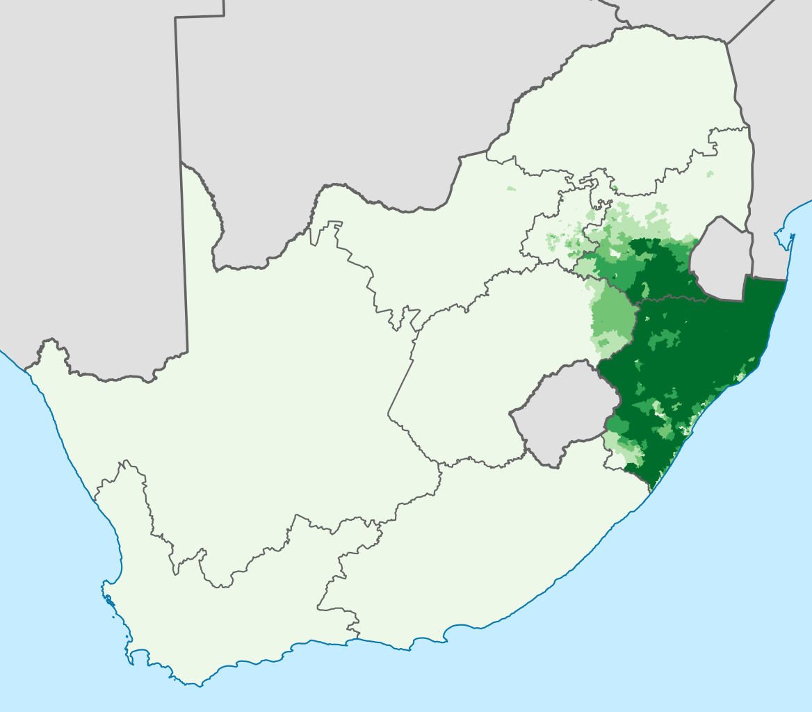
English: Proportion of the South African population that speaks isiZulu as their first language, according to Census 2011 at electoral ward level
0–20%
20–40%
40–60%
60–80%
80–100%
Projection is Albers Equal-Area Conic, with standard parallels at 25.5° S and 31.5° S, and origin at 28.5° S 25.5° E. |
| Petsa | |
| Taudan | Statistics South Africa's Census 2011 is the source of the basic population data. The map results from my own processing of the data. For ward boundaries see File:South Africa electoral wards 2011 blank.svg. |
| Mannurat | Htonl |
Lisensia
The following license applies to the population data on which the map is based:

|
Ti nagtengngel ti karbengan ti kopia iti daytoy a papeles, Stats SA, ket mangipalubos ti sinoman nga agusar para iti ania man a panggep, no maipasaganaan a ti nagtengngel ti karbengan ti kopia ket maitutop a mapadayawan. Ti panagiwaras, deribatibo nga obra, komersial a panagusar, ken amin a maipalubos a panagusar. |
Pammadayaw:
"the user acknowledges Stats SA as the source of the basic data wherever they process, apply, utilise, publish or distribute the data, and also that they specify that the relevant application and analysis (where applicable) result from their own processing of the data" [1]
|
The following tag applies to the map itself:
| Siak, ti agtengtengel ti karbengan ti kopia iti daytoy nga obra, ibbatak daytoy nga obra iti pagturayan a publiko. Daytoy ket maipakat iti sangalubongan. Kadagiti sabali a pagilian daytoy ket saan a mabalin a nalinteg; no kastoy ket: Siak ket agit-ited iti sinoman ti karbengan nga agusar iti daytoy nga obra para iti ania man a panggep, nga awan dagiti kasasaad, malaksid no adda dagiti kasasaad a masapul babaen ti linteg. |
Pakasaritaan ti papeles
Pinduten iti petsa/oras tapno makita ti papeles a kas naiparang iti dayta a panawen.
| Petsa/Oras | Bassit a ladawan | Dagiti rukod | Agar-aramat | Komentario | |
|---|---|---|---|---|---|
| agdama | 22:30, 5 Septiembre 2013 | | 809 × 709 (534 KB) | Htonl | == {{int:filedesc}} == {{Information |Description={{en|1=Proportion of the South African population that speaks isiZulu as their first language, according to Census 2011 at electoral ward level {{legend|#EDF8E9|0–20%}} {{legend|#BAE4B3|20–40%}} {{l... |
Panagusar iti papeles
Ti sumaganad a panid ket agus-usar iti daytoy a papeles:
Global a panagusar ti papeles
Dagiti sumaganad a wiki ket agus-usar iti daytoy a papeles:
- Panagusar idiay af.wikipedia.org
- Panagusar idiay am.wikipedia.org
- Panagusar idiay ar.wikipedia.org
- Panagusar idiay arz.wikipedia.org
- Panagusar idiay azb.wikipedia.org
- Panagusar idiay be.wikipedia.org
- Panagusar idiay bn.wikipedia.org
- Panagusar idiay ca.wikipedia.org
- Panagusar idiay cs.wikipedia.org
- Panagusar idiay cv.wikipedia.org
- Panagusar idiay de.wikipedia.org
- Panagusar idiay en.wikipedia.org
- Panagusar idiay eo.wikipedia.org
- Panagusar idiay et.wikipedia.org
- Panagusar idiay eu.wikipedia.org
- Panagusar idiay fa.wikipedia.org
- Panagusar idiay fi.wikipedia.org
- Panagusar idiay fo.wikipedia.org
- Panagusar idiay fr.wikipedia.org
- Panagusar idiay ga.wikipedia.org
- Panagusar idiay gl.wikipedia.org
- Panagusar idiay ha.wikipedia.org
- Panagusar idiay hu.wikipedia.org
- Panagusar idiay id.wikipedia.org
- Panagusar idiay ie.wikipedia.org
- Panagusar idiay ja.wikipedia.org
- Panagusar idiay kg.wikipedia.org
- Panagusar idiay ko.wikipedia.org
- Panagusar idiay kv.wikipedia.org
- Panagusar idiay mk.wikipedia.org
- Panagusar idiay ml.wikipedia.org
- Panagusar idiay mr.wikipedia.org
- Panagusar idiay mzn.wikipedia.org
- Panagusar idiay nl.wikipedia.org
- Panagusar idiay nn.wikipedia.org
- Panagusar idiay no.wikipedia.org
- Panagusar idiay nso.wikipedia.org
- Panagusar idiay oc.wikipedia.org
- Panagusar idiay pl.wikipedia.org
Kitaen ti adu pay a global a panagusar iti daytoy a papeles.