Papeles:Taal Volcano-Pansipit River satellite image.gif

Page contents not supported in other languages.
Daytoy ket papeles a nagtaud manipud idiay Wikimedia Commons
Manipud iti Wikipedia, ti nawaya nga ensiklopedia

Taal_Volcano-Pansipit_River_satellite_image.gif(252 × 252 dagiti piksel, kadakkel ti papeles: 54 KB, kita ti MIME: image/gif)

Deskripsion A cropped version of
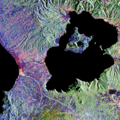
English: Lake Taal and Taal Volcano radar satellite image. From [1].
Emphasis on the Pansipit River-Taal Lake system.
Petsa (UTC)
Taudan
Mannurat


This is a retouched picture, which means that it has been digitally altered from its original version. Modifications: Cropped original photograph. The original can be viewed here: Taal Volcano satellite image.gif. Modifications made by Shrumster.


Public domain This file is in the public domain in the United States because it was solely created by NASA. NASA copyright policy states that "NASA material is not protected by copyright unless noted". (See Template:PD-USGov, NASA copyright policy page or JPL Image Use Policy.)
Warnings:

Kasisigud a listaan pang-ipan

This image is a derivative work of the following images:

  • Image:Taal_Volcano_satellite_image.gif licensed with PD-USGov-NASA, PD-USGov-NASA/copyright
    • 2008-01-10T19:07:55Z Rémih 450x472 (218708 Bytes) {{Information |Description={{en|Lake Taal and Taal Volcano radar satellite image. From [http://www.jpl.nasa.gov/radar/sircxsar/taal.html].}} |Source=Transferred from [http://en.wikipedia.org en.wikipedia] |Date=2005-03-08 (f

Uploaded with derivativeFX

Captions

Add a one-line explanation of what this file represents

Items portrayed in this file

mangipresenta

Pakasaritaan ti papeles

Pinduten iti petsa/oras tapno makita ti papeles a kas naiparang iti dayta a panawen.

Petsa/OrasBassit a ladawanDagiti rukodAgar-aramatKomentario
agdama16:09, 9 Disiembre 2008Bassit a ladawan para iti bersion manipud idi 16:09, 9 Disiembre 2008252 × 252 (54 KB)Shrumster{{Information |Description=A cropped version of {{en|Lake Taal and Taal Volcano radar satellite image. From [http://www.jpl.nasa.gov/radar/sircxsar/taal.html].}} Emphasis on the Pansipit River-Taal Lake system. |Source=*[[:Image:Taal_Volcano_satellite_ima

Ti sumaganad a panid ket agus-usar iti daytoy a papeles:

Global a panagusar ti papeles

Dagiti sumaganad a wiki ket agus-usar iti daytoy a papeles: