
Papeles:World map indicating tropics and subtropics.png
Kadakkel daytoy a panagipadas: 800 × 447 dagiti piksel. Sabali kadagiti resolusion: 320 × 179 dagiti piksel | 640 × 357 dagiti piksel | 1,024 × 572 dagiti piksel | 1,280 × 715 dagiti piksel | 2,000 × 1,117 dagiti piksel.
Kasisigud a papeles (2,000 × 1,117 dagiti piksel, kadakkel ti papeles: 131 KB, kita ti MIME: image/png)
| Daytoy ket papeles a nagtaud manipud idiay Wikimedia Commons. Ti pakaammo manipud iti bukodna a deskripsion a panid idiay ket naiparang dita baba. Ti Commons ket repositorio dagiti nawaya a nalisensiaan a midia. Mabalinmo ti tumulong. |
Pakabuklan
| Deskripsion |
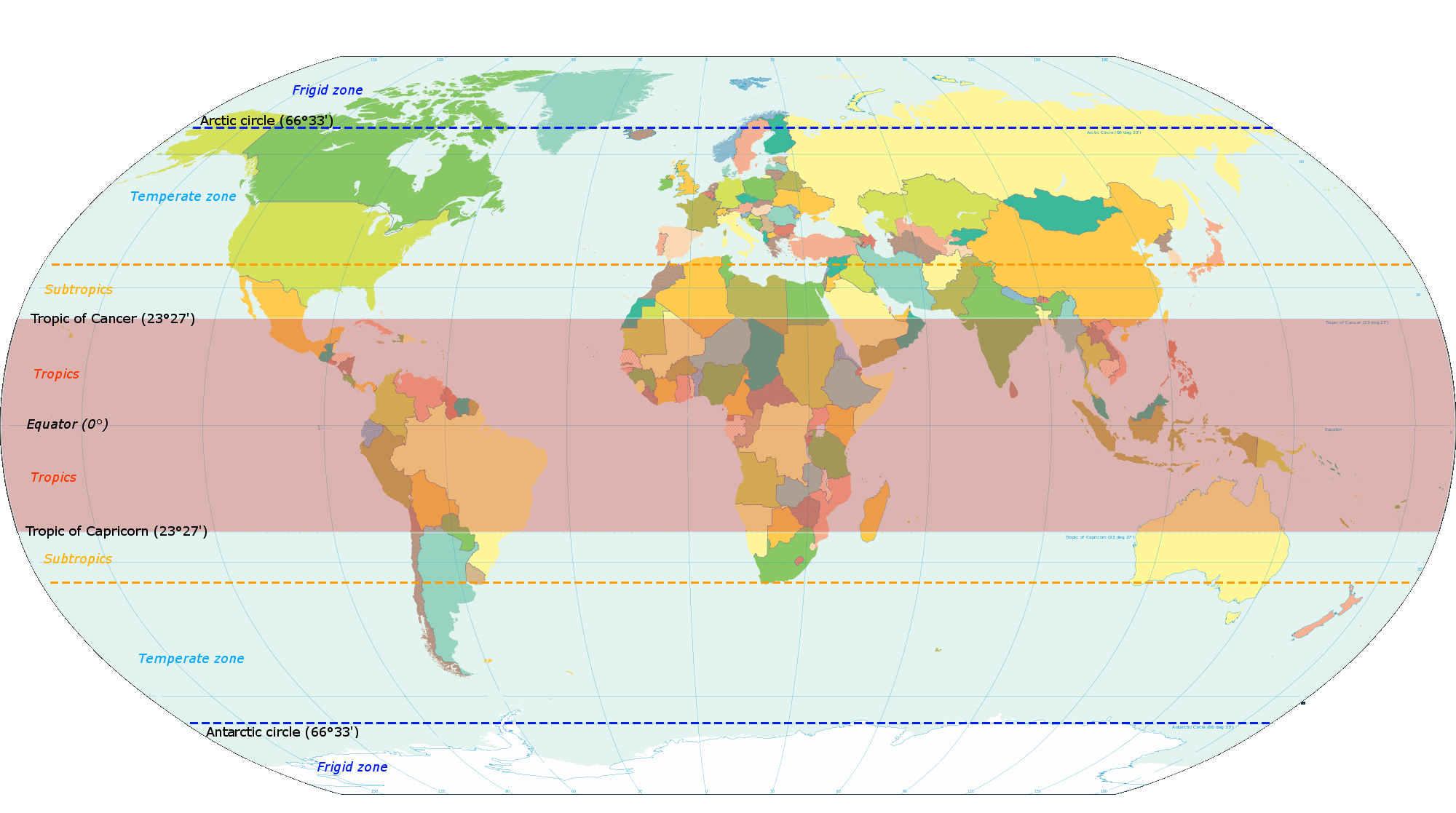
English: Map based on File:World map torrid.svg, now indicating subtropics. Map was made by closely examining this map to get latitude accurately correct. |
| Petsa | |
| Taudan | Bukod nga obra |
| Mannurat | KVDP |
Lisensia
Siak, ti agtengtengel ti karbengan ti kopia iti daytoy nga obra, ket agipablaak babaen ti sumaganad a lisensia:
Daytoy a papeles ket nalisensiaan babaen ti Creative Commons Attribution-Share Alike 3.0 Unported a lisensia.
- Nawaya ka:
- ti makibingay – ti ag-kopia, agiwaras ken agipatulod ti obra
- ti pagtipon-tipon – ti panagibagay ti obra
- Babaen kadagiti sumaganad a kasasaad:
- pammadayaw – Nasken a mangtedka iti pammadayaw, mangited iti silpo iti lisensia, ken mangibaga no adda dagiti nabaliwan. Mabalinmo nga aramiden iti ania man a pamay-an, ngem iti san a waya a mangisingasing a mangigupit kenka wenno iti panagusarmo.
- makibingay nga agpadapada – No laokam, baliwam, wenno agpartuat manipud iti dayata material, nasken nga iwaras dagiti kontribusionmo babaen ti kapada wenno maitunos a lisensia a kas ti kasisigud.
Pakasaritaan ti papeles
Pinduten iti petsa/oras tapno makita ti papeles a kas naiparang iti dayta a panawen.
| Petsa/Oras | Bassit a ladawan | Dagiti rukod | Agar-aramat | Komentario | |
|---|---|---|---|---|---|
| agdama | 18:13, 13 Marso 2014 | | 2,000 × 1,117 (131 KB) | Genetics4good | Reverted to version as of 10:31, 20 November 2013 |
| 18:09, 13 Marso 2014 |  | 2,000 × 1,117 (465 KB) | Genetics4good | Reverted to version as of 06:44, 23 July 2013 | |
| 10:31, 20 Nobiembre 2013 |  | 2,000 × 1,117 (131 KB) | Maproom | My fourth attempt. I am making a real mess of this. | |
| 18:46, 19 Nobiembre 2013 |  | 2,000 × 1,117 (131 KB) | Maproom | A third attempt, with the corrections AND the transparency this time, I hope. | |
| 10:28, 13 Nobiembre 2013 |  | 2,000 × 1,117 (131 KB) | Maproom | Restored background transparency, which I had accidentally removed | |
| 10:23, 13 Nobiembre 2013 |  | 2,000 × 1,117 (422 KB) | Maproom | Removed labels "68" on two lines of latitude - the lines are in the right position (as limits of subtropical zone), but are not at 68 north and south. Added a "c" to "Antarctic". | |
| 06:44, 23 Hulio 2013 |  | 2,000 × 1,117 (465 KB) | Genetics4good | Added temperate and frigid zone | |
| 15:53, 22 Hulio 2013 |  | 2,000 × 1,117 (452 KB) | Genetics4good | User created page with UploadWizard |
Panagusar iti papeles
Ti sumaganad a 2 a pampanid ket agus-usar iti daytoy a papeles:
Global a panagusar ti papeles
Dagiti sumaganad a wiki ket agus-usar iti daytoy a papeles:
- Panagusar idiay ar.wikipedia.org
- Panagusar idiay arz.wikipedia.org
- Panagusar idiay bg.wikipedia.org
- Panagusar idiay bh.wikipedia.org
- Panagusar idiay bn.wikipedia.org
- Panagusar idiay ca.wikipedia.org
- Panagusar idiay en.wikipedia.org
- Panagusar idiay en.wikiversity.org
- Panagusar idiay en.wikivoyage.org
- Panagusar idiay en.wiktionary.org
- Panagusar idiay fi.wikipedia.org
- Panagusar idiay fi.wiktionary.org
- Panagusar idiay ga.wikipedia.org
- Panagusar idiay gv.wikipedia.org
- Panagusar idiay ha.wikipedia.org
- Panagusar idiay he.wikivoyage.org
- Panagusar idiay id.wikipedia.org
- Panagusar idiay ms.wikipedia.org
- Panagusar idiay my.wikipedia.org
- Panagusar idiay ro.wikipedia.org
- Panagusar idiay sco.wikipedia.org
- Panagusar idiay sd.wikipedia.org
- Panagusar idiay sr.wikipedia.org
- Panagusar idiay su.wikipedia.org
- Panagusar idiay th.wikipedia.org
- Panagusar idiay tr.wikipedia.org
- Panagusar idiay ur.wikipedia.org
- Panagusar idiay war.wikipedia.org
- Panagusar idiay www.wikidata.org
- Panagusar idiay zh-yue.wikipedia.org
- Panagusar idiay zh.wikipedia.org