
Papeles:Zamboanga province map 1918.JPG
Kadakkel daytoy a panagipadas: 361 × 599 dagiti piksel. Sabali kadagiti resolusion: 145 × 240 dagiti piksel | 617 × 1,023 dagiti piksel.
Kasisigud a papeles (617 × 1,023 dagiti piksel, kadakkel ti papeles: 257 KB, kita ti MIME: image/jpeg)
| Daytoy ket papeles a nagtaud manipud idiay Wikimedia Commons. Ti pakaammo manipud iti bukodna a deskripsion a panid idiay ket naiparang dita baba. Ti Commons ket repositorio dagiti nawaya a nalisensiaan a midia. Mabalinmo ti tumulong. |
Pakabuklan
| Deskripsion |
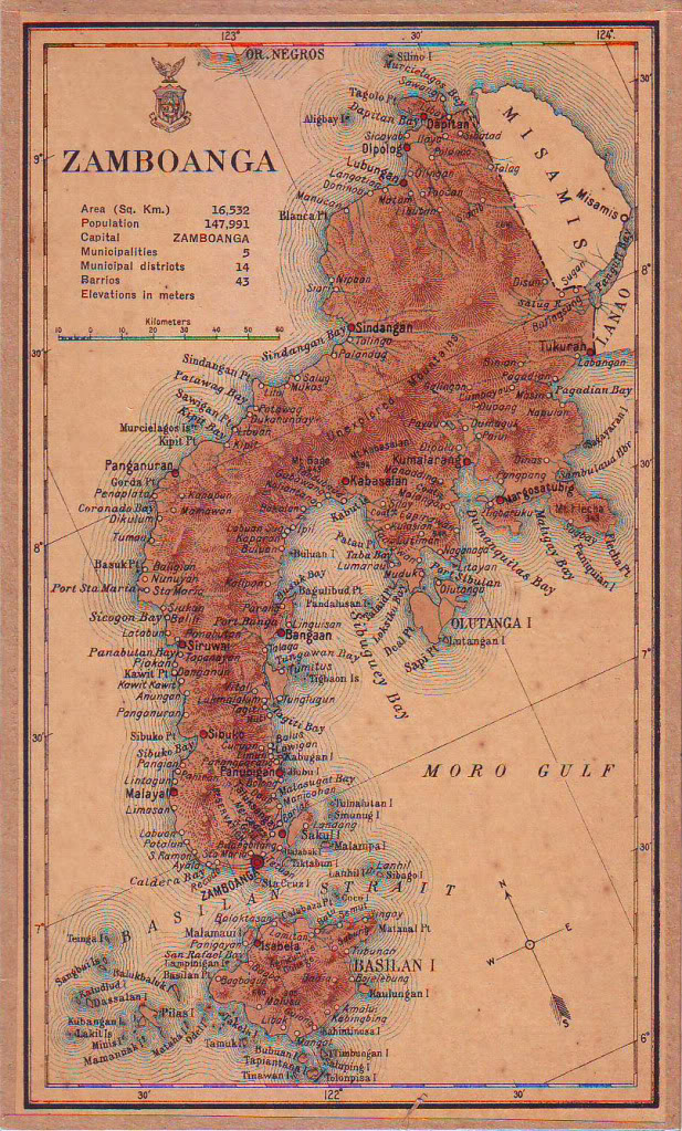
English: Map of Zamboanga province in 1918 |
| Petsa | |
| Taudan | Census of the Philippine Islands (1918) |
| Mannurat | Census Office of the Philippine Islands |
Lisensia
This media file is in the public domain in the United States. This applies to U.S. works where the copyright has expired, often because its first publication occurred prior to January 1, 1929, and if not then due to lack of notice or renewal. See this page for further explanation.
|
 | |
 |
This image might not be in the public domain outside of the United States; this especially applies in the countries and areas that do not apply the rule of the shorter term for US works, such as Canada, Mainland China (not Hong Kong or Macao), Germany, Mexico, and Switzerland. The creator and year of publication are essential information and must be provided. See Wikipedia:Public domain and Wikipedia:Copyrights for more details.
|
Pakasaritaan ti papeles
Pinduten iti petsa/oras tapno makita ti papeles a kas naiparang iti dayta a panawen.
| Petsa/Oras | Bassit a ladawan | Dagiti rukod | Agar-aramat | Komentario | |
|---|---|---|---|---|---|
| agdama | 04:13, 3 Agosto 2015 | | 617 × 1,023 (257 KB) | Namayan | User created page with UploadWizard |
Panagusar iti papeles
Ti sumaganad a panid ket agus-usar iti daytoy a papeles:
Global a panagusar ti papeles
Dagiti sumaganad a wiki ket agus-usar iti daytoy a papeles:
- Panagusar idiay bcl.wikipedia.org
- Panagusar idiay en.wikipedia.org
- Panagusar idiay es.wikipedia.org
- Panagusar idiay ka.wikipedia.org
- Panagusar idiay tl.wikipedia.org