
Papeles:Asia Köppen Map.png
Kadakkel daytoy a panagipadas: 760 × 599 dagiti piksel. Sabali kadagiti resolusion: 304 × 240 dagiti piksel | 609 × 480 dagiti piksel | 974 × 768 dagiti piksel | 1,280 × 1,009 dagiti piksel | 2,560 × 2,019 dagiti piksel | 2,749 × 2,168 dagiti piksel.
Kasisigud a papeles (2,749 × 2,168 dagiti piksel, kadakkel ti papeles: 1.49 MB, kita ti MIME: image/png)
| Daytoy ket papeles a nagtaud manipud idiay Wikimedia Commons. Ti pakaammo manipud iti bukodna a deskripsion a panid idiay ket naiparang dita baba. Ti Commons ket repositorio dagiti nawaya a nalisensiaan a midia. Mabalinmo ti tumulong. |
| Peel, M. C. and Finlayson, B. L. and McMahon, T. A. (2007). "Updated world map of the Köppen-Geiger climate classification". Hydrol. Earth Syst. Sci. 11: 1633-1644. ISSN 1027-5606. |
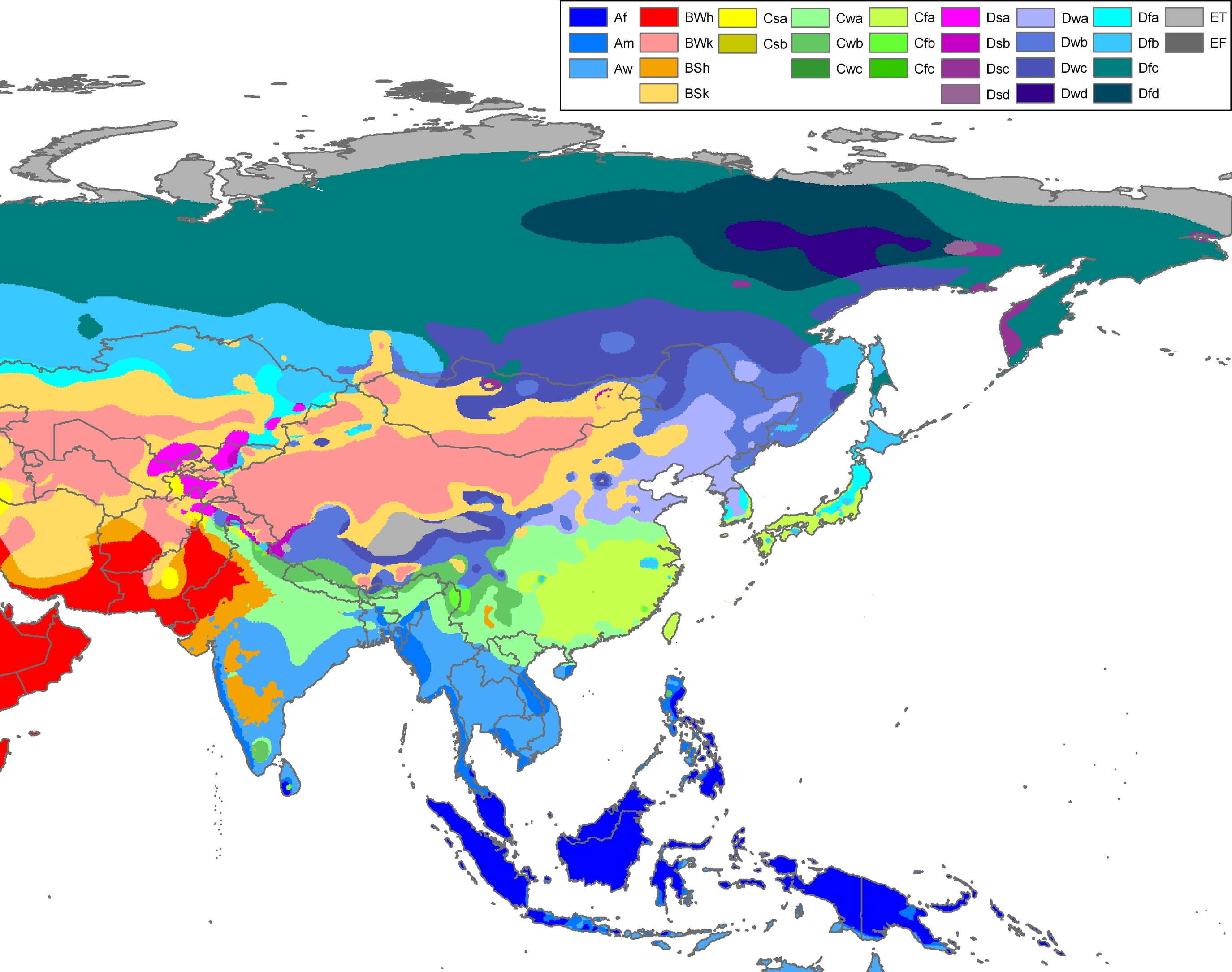
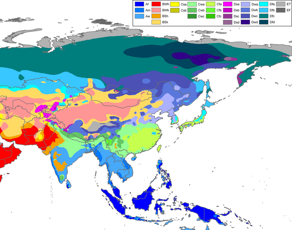
Legend
Pakabuklan
| Deskripsion | Climate map of Asia, excluding (South)west-Asia (from the "Updated world map of the Köppen-Geiger climate classification"). |
| Petsa | |
| Taudan | Hydrology and Earth System Sciences: "Updated world map of the Köppen-Geiger climate classification" (Supplement) - Original file was a JPG-file, this file is has been converted to a PNG-file, without extra modifications, by me (Jeroen). |
| Mannurat |
Peel, M. C., Finlayson, B. L., and McMahon, T. A. (University of Melbourne) |
| Pammalubos (Ti panagusar manen iti daytoy a papeles) |
Related maps
User Jeroenvrp made for these continents and areas a cropped and resized version:
- Africa Köppen Map.png
- Asia Köppen Map.png
- Australia-Oceania Köppen Map.png
- Europe Köppen Map.png
- North America Köppen Map.png
- Russia Köppen Map.png
- South America Köppen Map.png
- West Asia Köppen Map.png.
User LordToran made from the same data these maps:
- Klimagürtel-der-erde-eisklima.png
- Klimagürtel-der-erde-gemäßigte-zone.png
- Klimagürtel-der-erde-polargebiete.png
- Klimagürtel-der-erde-subtropen.png
- Klimagürtel-der-erde-tropen.png
- Klimagürtel-der-erde-tundra.png
- Klimagürtel-der-erde-warmgemäßigte-zone.png
- Klimagürtel-der-erde.png
- Klimagürtel-der-erde.svg
- Klimate-humidität.png
- Köppen-geiger-hessd-2007.svg
- Köppen-vereinfacht.svg
- Trockenklimate.png
Lisensia
Daytoy a papeles ket nalisensiaan babaen ti Creative Commons Attribution-Share Alike 3.0 Unported a lisensia.
- Nawaya ka:
- ti makibingay – ti ag-kopia, agiwaras ken agipatulod ti obra
- ti pagtipon-tipon – ti panagibagay ti obra
- Babaen kadagiti sumaganad a kasasaad:
- pammadayaw – Nasken a mangtedka iti pammadayaw, mangited iti silpo iti lisensia, ken mangibaga no adda dagiti nabaliwan. Mabalinmo nga aramiden iti ania man a pamay-an, ngem iti san a waya a mangisingasing a mangigupit kenka wenno iti panagusarmo.
- makibingay nga agpadapada – No laokam, baliwam, wenno agpartuat manipud iti dayata material, nasken nga iwaras dagiti kontribusionmo babaen ti kapada wenno maitunos a lisensia a kas ti kasisigud.

|
This map of asia image could be re-created using vector graphics as an SVG file. This has several advantages; see Commons:Media for cleanup for more information. If an SVG form of this image is available, please upload it and afterwards replace this template with
{{vector version available|new image name}}.
It is recommended to name the SVG file “Asia Köppen Map.svg”—then the template Vector version available (or Vva) does not need the new image name parameter. |
Pakasaritaan ti papeles
Pinduten iti petsa/oras tapno makita ti papeles a kas naiparang iti dayta a panawen.
| Petsa/Oras | Bassit a ladawan | Dagiti rukod | Agar-aramat | Komentario | |
|---|---|---|---|---|---|
| agdama | 22:51, 12 Oktubre 2007 | | 2,749 × 2,168 (1.49 MB) | Jeroen | Citation: '''Peel, M. C., Finlayson, B. L., and McMahon, T. A.: Updated world map of the Köppen-Geiger climate classification, Hydrol. Earth Syst. Sci., 11, 1633-1644, 2007.''' {{Information |Description= Climate map of Africa (from the "[[:Image:Worl |
Panagusar iti papeles
Ti sumaganad a panid ket agus-usar iti daytoy a papeles:
Global a panagusar ti papeles
Dagiti sumaganad a wiki ket agus-usar iti daytoy a papeles:
- Panagusar idiay cs.wikipedia.org
- Panagusar idiay en.wikipedia.org
- Panagusar idiay eo.wikipedia.org
- Panagusar idiay es.wikipedia.org
- Panagusar idiay es.wikibooks.org
- Panagusar idiay fy.wikipedia.org
- Panagusar idiay gl.wikipedia.org
- Panagusar idiay id.wikipedia.org
- Panagusar idiay ja.wikipedia.org
- Panagusar idiay mk.wikipedia.org
- Panagusar idiay nl.wikipedia.org
- Panagusar idiay pt.wikipedia.org
- Panagusar idiay simple.wikipedia.org
- Panagusar idiay sl.wikipedia.org
- Panagusar idiay th.wikipedia.org
- Panagusar idiay tr.wikipedia.org
- Panagusar idiay vi.wikipedia.org
- Panagusar idiay zea.wikipedia.org