
Papeles:London Thames Sunset panorama - Feb 2008.jpg

Kadakkel daytoy a panagipadas: 800 × 297 dagiti piksel. Sabali kadagiti resolusion: 320 × 119 dagiti piksel | 640 × 238 dagiti piksel | 1,024 × 380 dagiti piksel | 1,280 × 475 dagiti piksel | 2,560 × 951 dagiti piksel | 13,126 × 4,876 dagiti piksel.
Kasisigud a papeles (13,126 × 4,876 dagiti piksel, kadakkel ti papeles: 17.7 MB, kita ti MIME: image/jpeg)
| Daytoy ket papeles a nagtaud manipud idiay Wikimedia Commons. Ti pakaammo manipud iti bukodna a deskripsion a panid idiay ket naiparang dita baba. Ti Commons ket repositorio dagiti nawaya a nalisensiaan a midia. Mabalinmo ti tumulong. |
Pakabuklan
| Deskripsion |
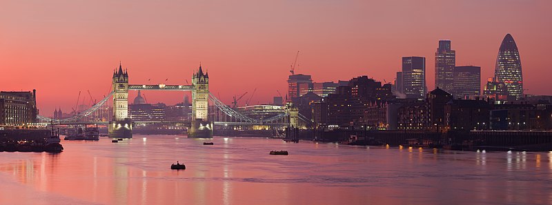
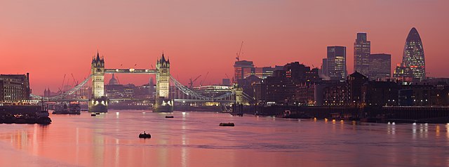
العربية: صُورة پانوراميَّة من عدَّة مقاطع لأُفق لندن من على ضفَّة برموندساي لنهر التيمز.
Čeština: Podvečerní panorama Londýna
English: A multi segment panoramic image of the London skyline from the Bermondsey banks of the Thames, in which the Tower Bridge and 30 St Mary Axe are visible.
|
| Petsa | Pebrero 2008 (18 Pebrero 2008, according to Exif data) |
| Taudan | Bukod nga obra |
| Mannurat | Diliff |
| Pammalubos (Ti panagusar manen iti daytoy a papeles) |
Summary:In using this image or any subsequent derivatives of it, you are required to release the image under the same license. As such, any reproduction of this image, in any medium, must appear with a copy of, or full URL of the license.Attribution of this image to the author (DAVID ILIFF) is also required, preferably in a prominent location near the image.No other conditions may be added to, or removed from this license without the permission of the author and copyright holder.Suggested attribution: "Photo by DAVID ILIFF. License: CC BY-SA 3.0"Please review the full license requirements carefully before using this image. If you would like to clarify the terms of the license or negotiate less restrictive commercial licensing outside of the bounds of GFDL/CC-BY-SA, please contact me by email, or if you don't have a Wikipedia account you can either leave a message on my talk page with your contact details and your request, or you can contact me on Facebook. Please also send a 'friend request' to ensure that I am aware of your message. |
| Dagiti sabali a bersion |
Derivative works of this file: |
| Camera location | | View this and other nearby images on: OpenStreetMap |
|---|
|

.jpg)
This image was selected as picture of the day on Wikimedia Commons for 27 July 2012. It was captioned as follows: Other languages:
Русский: Панорама Лондона, столицы Олимпийских игр 2012 года മലയാളം : ലണ്ടൻ, 2012 ഒളിമ്പിക്സിന്റെ ആതിഥേയ പട്ടണം. |
Lisensia
Siak, ti agtengtengel ti karbengan ti kopia iti daytoy nga obra, ket agipablaak babaen kadagiti sumaganad a lisensia:

|
Maited ti pammalubos ti agkopia, agiwaras ken/wenno mangbaliw iti daytoy a dokumento babaen ti termino iti GNU Free Documentation License, Bersion 1.2 wenno ti ania man a kinaudi a bersion babaen ti Free Software Foundation; nga awan dagiti Sabsabali a Paset, awan dagiti Sanguan nga Aklub a Teksto, ken dagiti Likudan nga Aklub a Teksto. Ti kopia ti lisensia ket nairaman iti paset a natituluan iti GNU Free Documentation License. |
Daytoy a papeles ket nalisensiaan babaen ti Creative Commons Attribution 3.0 Unported a lisensia.
- Nawaya ka:
- ti makibingay – ti ag-kopia, agiwaras ken agipatulod ti obra
- ti pagtipon-tipon – ti panagibagay ti obra
- Babaen kadagiti sumaganad a kasasaad:
- pammadayaw – Nasken a mangtedka iti pammadayaw, mangited iti silpo iti lisensia, ken mangibaga no adda dagiti nabaliwan. Mabalinmo nga aramiden iti ania man a pamay-an, ngem iti san a waya a mangisingasing a mangigupit kenka wenno iti panagusarmo.
Mabalinmo ti agpili kadagiti lisensia a kaykayatmo.
Pakasaritaan ti papeles
Pinduten iti petsa/oras tapno makita ti papeles a kas naiparang iti dayta a panawen.
| Petsa/Oras | Bassit a ladawan | Dagiti rukod | Agar-aramat | Komentario | |
|---|---|---|---|---|---|
| agdama | 17:39, 18 Mayo 2015 | 13,126 × 4,876 (17.7 MB) | Diliff | fixed stitching error | |
| 17:26, 10 Mayo 2015 | 13,126 × 4,876 (17.63 MB) | Diliff | higher resolution version | ||
| 13:23, 1 Marso 2008 | 2,500 × 932 (685 KB) | Diliff | {{Information |Description=A multi segment panoramic image of the London skyline from the Bermondsey banks of the Thames. Taken by myself with a Canon 5D and 70-200mm f/2.8L lens. |Source=self-made |Date=Feb 2008 |Author= Diliff |Permissio |
Panagusar iti papeles
Ti sumaganad a 6 a pampanid ket agus-usar iti daytoy a papeles:
- Plantilia:Napili a ladawan ita nga aldaw/Abril 21
- Plantilia:Napili a ladawan ita nga aldaw/Agosto 21
- Plantilia:Napili a ladawan ita nga aldaw/Disiembre 21
- Plantilia:Napili a ladawan ita nga aldaw/Hunio 21
- Plantilia:Napili a ladawan ita nga aldaw/Oktubre 21
- Plantilia:Napili a ladawan ita nga aldaw/Pebrero 21
Global a panagusar ti papeles
Dagiti sumaganad a wiki ket agus-usar iti daytoy a papeles:
- Panagusar idiay ace.wikipedia.org
- Panagusar idiay af.wikipedia.org
- Panagusar idiay am.wikipedia.org
- Panagusar idiay ar.wikipedia.org
- نهر التمز
- مستخدم:ديفيد/صور ساهمت في جعلها مختارة
- بوابة:إنجلترا/صورة مختارة
- بوابة:إنجلترا/صورة مختارة/أرشيف
- ويكيبيديا:ترشيحات الصور المختارة/جسر البرج بلندن
- بوابة:إنجلترا/صورة مختارة/9
- ويكيبيديا:صور مختارة/أماكن/رؤية شاملة
- بوابة:أوروبا/صورة مختارة/أرشيف
- بوابة:أوروبا/صورة مختارة/8
- ويكيبيديا:صورة اليوم المختارة/يوليو 2015
- قالب:صورة اليوم المختارة/2015-07-14
- ويكيبيديا:صورة اليوم المختارة/سبتمبر 2016
- قالب:صورة اليوم المختارة/2016-09-21
- ويكيبيديا:صورة اليوم المختارة/يوليو 2018
- قالب:صورة اليوم المختارة/2018-07-10
- ويكيبيديا:صورة اليوم المختارة/يوليو 2021
- قالب:صورة اليوم المختارة/2021-07-05
- Panagusar idiay ast.wikipedia.org
- Panagusar idiay azb.wikipedia.org
- Panagusar idiay ban.wikipedia.org
- Panagusar idiay bcl.wikipedia.org
- Panagusar idiay be-tarask.wikipedia.org
- Panagusar idiay be.wikipedia.org
- Panagusar idiay bh.wikipedia.org
- Panagusar idiay bn.wikipedia.org
- Panagusar idiay bn.wikivoyage.org
- Panagusar idiay bo.wikipedia.org
- Panagusar idiay br.wikipedia.org
- Panagusar idiay bs.wikipedia.org
- Panagusar idiay crh.wikipedia.org
- Panagusar idiay cv.wikipedia.org
- Panagusar idiay cy.wikipedia.org
- Panagusar idiay da.wikipedia.org
- Panagusar idiay de.wikipedia.org
Kitaen ti adu pay a global a panagusar iti daytoy a papeles.