
Papeles:Naval Station Sangley Point aerial1 c1964.jpg

Kadakkel daytoy a panagipadas: 800 × 463 dagiti piksel. Sabali kadagiti resolusion: 320 × 185 dagiti piksel | 810 × 469 dagiti piksel.
Kasisigud a papeles (810 × 469 dagiti piksel, kadakkel ti papeles: 248 KB, kita ti MIME: image/jpeg)
| Daytoy ket papeles a nagtaud manipud idiay Wikimedia Commons. Ti pakaammo manipud iti bukodna a deskripsion a panid idiay ket naiparang dita baba. Ti Commons ket repositorio dagiti nawaya a nalisensiaan a midia. Mabalinmo ti tumulong. |
Pakabuklan
| Deskripsion |
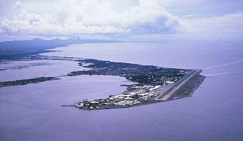
English: An aerial view of the Cavite Peninsula (circa 1963-1966) in Manila Bay, Philippines with the U.S. Naval Station Sangley Point in the foreground and Cavite City behind the base. Bacoor Bay is the body of water at the leftmost center of the picture near the mainland and Cañacao Bay is to the left of the naval base. |
| Petsa | circa 1963-1966 |
| Taudan | U.S. Navy Cdr. Bigley website [1] |
| Mannurat | Cdr. T. L. Bigley, USNR-TAR (Retired), VP-40 1963-1966 |
| Camera location | | View this and other nearby images on: OpenStreetMap |
|---|
Lisensia
This file is a work of a sailor or employee of the U.S. Navy, taken or made as part of that person's official duties. As a work of the U.S. federal government, it is in the public domain in the United States.
|
 | |
| Daytoy a papeles ket nainaganan a kas nawaya iti amin nga ammo a pakedngan babaen ti karbengan ti kopia a linteg, a mairaman amin a dagiti makaibagian ken karruba a karbengan. | ||
Pakasaritaan ti papeles
Pinduten iti petsa/oras tapno makita ti papeles a kas naiparang iti dayta a panawen.
| Petsa/Oras | Bassit a ladawan | Dagiti rukod | Agar-aramat | Komentario | |
|---|---|---|---|---|---|
| agdama | 21:28, 7 Abril 2010 | | 810 × 469 (248 KB) | Cobatfor | == {{int:filedesc}} == {{Information |Description=Aerial view of the U.S. Naval Station Sangley Point, Philippines, circa 1963-1966. |Source=U.S. Navy Cdr. Bigley website [http://home.earthlink.net/~patron40/] |Date={{other date|ca|1963-1966}} |Author=Cdr |
Panagusar iti papeles
Ti sumaganad a panid ket agus-usar iti daytoy a papeles:
Global a panagusar ti papeles
Dagiti sumaganad a wiki ket agus-usar iti daytoy a papeles:
- Panagusar idiay ceb.wikipedia.org
- Panagusar idiay en.wikipedia.org
- Panagusar idiay en.wikivoyage.org
- Panagusar idiay es.wikipedia.org
- Panagusar idiay lv.wikipedia.org
- Panagusar idiay www.wikidata.org