
Papeles:Ph Territorial Map.png

Kadakkel daytoy a panagipadas: 584 × 600 dagiti piksel. Sabali kadagiti resolusion: 234 × 240 dagiti piksel | 467 × 480 dagiti piksel | 748 × 768 dagiti piksel | 997 × 1,024 dagiti piksel | 1,827 × 1,877 dagiti piksel.
Kasisigud a papeles (1,827 × 1,877 dagiti piksel, kadakkel ti papeles: 612 KB, kita ti MIME: image/png)
| Daytoy ket papeles a nagtaud manipud idiay Wikimedia Commons. Ti pakaammo manipud iti bukodna a deskripsion a panid idiay ket naiparang dita baba. Ti Commons ket repositorio dagiti nawaya a nalisensiaan a midia. Mabalinmo ti tumulong. |

|
This map image could be re-created using vector graphics as an SVG file. This has several advantages; see Commons:Media for cleanup for more information. If an SVG form of this image is available, please upload it and afterwards replace this template with
{{vector version available|new image name}}.
It is recommended to name the SVG file “Ph Territorial Map.svg”—then the template Vector version available (or Vva) does not need the new image name parameter. |
Pakabuklan
| Deskripsion |
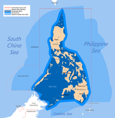
English: Territorial map claimed by the Philippines, showing internal waters, territorial sea, international treaty limits and exclusive economic zone. |
| Petsa | 25 Hunio 2007 (original upload) |
| Taudan | English Wikipedia (log) |
| Mannurat | Roel Balingit (username: Namayan); addition of Benham Rise and Indo-PH EEZs: Ervin Malicdem (schadow1) |
Lisensia
Ni Roel Balingit (username: Namayan), ti agtengtengel ti karbengan ti kopia iti daytoy nga obra, ket agipablaak babaen kadagiti sumaganad a lisensia:

|
Maited ti pammalubos ti agkopia, agiwaras ken/wenno mangbaliw iti daytoy a dokumento babaen ti termino iti GNU Free Documentation License, Bersion 1.2 wenno ti ania man a kinaudi a bersion babaen ti Free Software Foundation; nga awan dagiti Sabsabali a Paset, awan dagiti Sanguan nga Aklub a Teksto, ken dagiti Likudan nga Aklub a Teksto. Ti kopia ti lisensia ket nairaman iti paset a natituluan iti GNU Free Documentation License. |
Daytoy a papeles ket nalisensiaan babaen ti Creative Commons Attribution 2.5 Generic a lisensia.
Pammadayaw: Roel Balingit (username: Namayan)
- Nawaya ka:
- ti makibingay – ti ag-kopia, agiwaras ken agipatulod ti obra
- ti pagtipon-tipon – ti panagibagay ti obra
- Babaen kadagiti sumaganad a kasasaad:
- pammadayaw – Nasken a mangtedka iti pammadayaw, mangited iti silpo iti lisensia, ken mangibaga no adda dagiti nabaliwan. Mabalinmo nga aramiden iti ania man a pamay-an, ngem iti san a waya a mangisingasing a mangigupit kenka wenno iti panagusarmo.
Mabalinmo ti agpili kadagiti lisensia a kaykayatmo.
Pakasaritaan ti papeles
Pinduten iti petsa/oras tapno makita ti papeles a kas naiparang iti dayta a panawen.
| Petsa/Oras | Bassit a ladawan | Dagiti rukod | Agar-aramat | Komentario | |
|---|---|---|---|---|---|
| agdama | 05:58, 19 Hulio 2015 | | 1,827 × 1,877 (612 KB) | Schadow1 | Extending EEZ boundaries to include Benham Rise Extended EEZ and Philippines-Indonesia EEZ Delimitation Agreement |
| 11:33, 8 Mayo 2012 |  | 1,827 × 1,790 (535 KB) | Sky Harbor | Reverted to version as of 16:54, 28 August 2009. The name "West Philippine Sea" is a neologism and is not neutral. | |
| 08:13, 4 Mayo 2012 |  | 612 × 600 (129 KB) | Jeromesandilanico | Change of name as West Philippine Sea as used to describe the Philippines official claim as used by the Philippine Government and Media. | |
| 16:54, 28 Agosto 2009 |  | 1,827 × 1,790 (535 KB) | Mormegil | {{Information |Description= {{en|Territorial map of the Philippines, showing internal waters, territorial sea, international treaty limits and exclusive economic zone.}} |Source=English Wikipedia |Date={{date|2007-0 |
Panagusar iti papeles
Ti sumaganad a panid ket agus-usar iti daytoy a papeles:
Global a panagusar ti papeles
Dagiti sumaganad a wiki ket agus-usar iti daytoy a papeles:
- Panagusar idiay af.wikipedia.org
- Panagusar idiay bn.wikipedia.org
- Panagusar idiay cs.wikipedia.org
- Panagusar idiay de.wikipedia.org
- Panagusar idiay en.wikipedia.org
- Scarborough Shoal
- User:Namayan
- Philippines and the Spratly Islands
- Wikipedia talk:Tambayan Philippines/Archive 16
- Spratly Islands dispute
- Wikipedia:Graphics Lab/Map workshop/Archive/Apr 2013
- Wikipedia:Graphics Lab/Map workshop/Archive/May 2014
- Baselines of the Philippines
- Borders of the Philippines
- User:TagaSanPedroAko/Original contents of Presidency of Rodrigo Duterte
- User:Jose Edmundo Dayot/PIL Module 4
- Panagusar idiay fr.wikipedia.org
- Panagusar idiay gl.wikipedia.org
- Panagusar idiay he.wikipedia.org
- Panagusar idiay he.wiktionary.org
- Panagusar idiay io.wikipedia.org
- Panagusar idiay it.wikipedia.org
- Panagusar idiay ja.wikipedia.org
- Panagusar idiay ka.wikipedia.org
- Panagusar idiay km.wikipedia.org
- Panagusar idiay kn.wikipedia.org
- Panagusar idiay mdf.wikipedia.org
- Panagusar idiay pa.wikipedia.org
- Panagusar idiay pl.wikipedia.org
- Panagusar idiay pnb.wikipedia.org
- Panagusar idiay sk.wikipedia.org
- Panagusar idiay th.wikipedia.org
- Panagusar idiay tl.wikipedia.org
- Panagusar idiay uk.wikipedia.org
Kitaen ti adu pay a global a panagusar iti daytoy a papeles.