
Papeles:Luzon Strait n7184.jpg

Kadakkel daytoy a panagipadas: 318 × 598 dagiti piksel. Sabali kadagiti resolusion: 127 × 240 dagiti piksel | 542 × 1,020 dagiti piksel.
Kasisigud a papeles (542 × 1,020 dagiti piksel, kadakkel ti papeles: 77 KB, kita ti MIME: image/jpeg)
| Daytoy ket papeles a nagtaud manipud idiay Wikimedia Commons. Ti pakaammo manipud iti bukodna a deskripsion a panid idiay ket naiparang dita baba. Ti Commons ket repositorio dagiti nawaya a nalisensiaan a midia. Mabalinmo ti tumulong. |
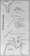
| Deskripsion | Old map of the Luzon Strait (not labeled), including the Bashi Channel, between Orchid Island (Botel Tobago on the map) of Taiwan and the Batan Islands of the Philippines. Names may be out of date. Japanese caption: "Islands between Taiwan and Luzon". | |||||
| Petsa | Di ammo a petsa | |||||
| Taudan |
From digital archive of the University of Tokyo. [1] Cropped by a-giâu. |
|||||
| Mannurat | anthropologist Torii Ryūzō (1870-1953) | |||||
| Pammalubos (Ti panagusar manen iti daytoy a papeles) |
|


Pakasaritaan ti papeles
Pinduten iti petsa/oras tapno makita ti papeles a kas naiparang iti dayta a panawen.
| Petsa/Oras | Bassit a ladawan | Dagiti rukod | Agar-aramat | Komentario | |
|---|---|---|---|---|---|
| agdama | 23:30, 11 Nobiembre 2004 | | 542 × 1,020 (77 KB) | A-giâu | Old map of the Luzon Strait,(not labeled), including the Bashi Channel, between Orchid Island (Botel Tobago in the map) of Taiwan and the Batanes of the Philippines. Names may be out of date. From digital archive of the Universit |
Panagusar iti papeles
Ti sumaganad a 2 a pampanid ket agus-usar iti daytoy a papeles:
Global a panagusar ti papeles
Dagiti sumaganad a wiki ket agus-usar iti daytoy a papeles:
- Panagusar idiay ar.wikipedia.org
- Panagusar idiay ast.wikipedia.org
- Panagusar idiay az.wikipedia.org
- Panagusar idiay bcl.wikipedia.org
- Panagusar idiay be.wikipedia.org
- Panagusar idiay ca.wikipedia.org
- Panagusar idiay ceb.wikipedia.org
- Panagusar idiay cs.wikipedia.org
- Panagusar idiay da.wikipedia.org
- Panagusar idiay de.wikipedia.org
- Panagusar idiay en.wikipedia.org
- Panagusar idiay es.wikipedia.org
- Panagusar idiay eu.wikipedia.org
- Panagusar idiay fa.wikipedia.org
- Panagusar idiay fr.wikipedia.org
- Panagusar idiay he.wikipedia.org
- Panagusar idiay hi.wikipedia.org
- Panagusar idiay id.wikipedia.org
- Panagusar idiay it.wikipedia.org
- Panagusar idiay ja.wikipedia.org
- Panagusar idiay ko.wikipedia.org
- Panagusar idiay lt.wikipedia.org
- Panagusar idiay mk.wikipedia.org
- Panagusar idiay nl.wikipedia.org
- Panagusar idiay no.wikipedia.org
- Panagusar idiay pam.wikipedia.org
Kitaen ti adu pay a global a panagusar iti daytoy a papeles.