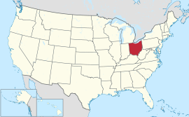
Ohio
Appearance
| Estado iti Ohio | |
|---|---|
| Birngas: The Buckeye State; The Mother of Presidents; Birthplace of Aviation; The Heart of It All | |
| Pasasao: With God, all things are possible | |
 | |
| Opisial a pagsasao | Awan. (Ingles, de facto) |
| Nagan dagiti umili | Ohioan; Buckeye |
| Kapitolio | Columbus |
| Kadakkelan a siudad | kapitolio |
| Kadakkelan a metro | Greater Cleveland wenno Greater Cincinnati |
| Kalawa | Maika-34 |
| - Dagup | 44,825 sq mi (116,096 km2) |
| - Kaakaba | 220-milia (355 km) |
| - Kaatiddog | 220-milia (355 km) |
| - % ti danum | 8.7 |
| - Latitud | 38° 24′ N to 41° 59′ N |
| - Longitud | 80° 31′ W to 84° 49′ W |
| Populasion | Maika-7 |
| - Dagup | 11,544,951 (2011 karkulo) |
| - Densidad | 282/sq mi (109/km2) Maika-10 |
| Kangato | |
| - Kangatuan a punto | Campbell Hill[1][2] 1,549 ft (472 m) |
| - Pagtengngaan | 850 ft (260 m) |
| - Kababaan a punto | Karayan Ohio iti nagbeddengan ti Indiana[1][2] 455 ft (139 m) |
| Sakbay a naestado | Northwest Territory |
| Pannakaawat iti kappon | Marso 1, 1803 (Maika-17) |
| Gobernador | John Kasich(R) |
| Teniente Gobernador | Mary Taylor(R) |
| Lehislatura | General Assembly |
| - Akinngato a Kamara | Senado |
| - Akinbaba a Kamara | House of Representatives |
| Dagiti senador | Sherrod Brown(D) Rob Portman(R) |
| Dagiti delegado | 13 Republikano, 5 Demokrata (listaan) |
| Sona ti oras | Dumaya: UTC-5/-4 |
| ISO 3166 | US-OH |
| Pangyababaan | OH, |
| Website | www |
Nagsasabtan: 40°30′N 82°30′W / 40.5°N 82.5°W
Ti Ohio ket maysa nga estado a mabirukan idiay tennga a laud iti Estados Unidos.
Dagiti nagibasaran
[urnosen | urnosen ti taudan]


